

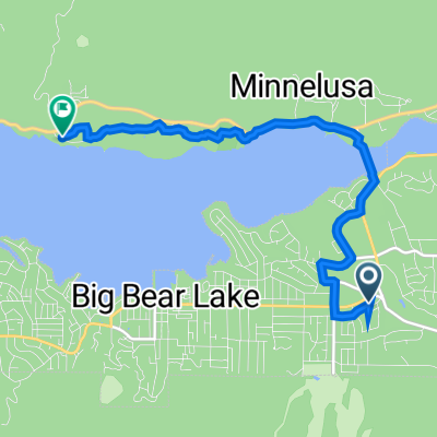
Dag 006 A Barton Flats Campground - Victorivile
A cycling route starting in Big Bear Lake, California, United States.
Overview
About this route
- -:--
- Duration
- 111.7 km
- Distance
- 681 m
- Ascent
- 1,876 m
- Descent
- ---
- Avg. speed
- ---
- Max. altitude
Route quality
Waytypes & surfaces along the route
Waytypes
Track
21.2 km
(19 %)
Quiet road
11.2 km
(10 %)
Surfaces
Paved
80.5 km
(72 %)
Unpaved
1.1 km
(1 %)
Asphalt
80.5 km
(72 %)
Unpaved (undefined)
1.1 km
(1 %)
Undefined
30.2 km
(27 %)
Route highlights
Points of interest along the route
Accommodation after 72.3 km
ROC Launch Site Cambria Road California 92356, United States rocstock.org
Accommodation after 109.2 km
Mojave Narrow Regional Park18000 Yates Rd Victorville, California 92392 GPS Coordinates: Latitude: 34.5075 Longitude: -117.2724
Accommodation after 111 km
San Bernardino County Fairgrounds14800 Seventh Street San Bernardino, California 92410 GPS Coordinates: Latitude: 34.521975 Longitude: -117.311332
Accommodation after 111.5 km
Victorville Shady Oasis Kampground 14800 Seventh Street San Bernardino, California 92410 GPS Coordinates: Latitude: 34.521975 Longitude: -117.311332 Soort KOA
Accommodation after 111.7 km
Hier is een motel Days inn 45 dollar meerdere hotels en eetgelegenheden Mexicaans familie restaurant.
Continue with Bikemap
Use, edit, or download this cycling route
You would like to ride Dag 006 A Barton Flats Campground - Victorivile or customize it for your own trip? Here is what you can do with this Bikemap route:
Free features
- Save this route as favorite or in collections
- Copy & plan your own version of this route
- Split it into stages to create a multi-day tour
- Sync your route with Garmin or Wahoo
Premium features
Free trial for 3 days, or one-time payment. More about Bikemap Premium.
- Navigate this route on iOS & Android
- Export a GPX / KML file of this route
- Create your custom printout (try it for free)
- Download this route for offline navigation
Discover more Premium features.
Get Bikemap PremiumFrom our community
Other popular routes starting in Big Bear Lake
 Goldsmiths to Alpine peddle path
- Distance
- 6.6 km
- Ascent
- 60 m
- Descent
- 78 m
- Location
- Big Bear Lake, California, United States
 39001 N Shore Dr, Fawnskin to 39001 N Shore Dr, Fawnskin
- Distance
- 46.9 km
- Ascent
- 255 m
- Descent
- 260 m
- Location
- Big Bear Lake, California, United States
 Dag 006 A Barton Flats Campground - Victorivile
- Distance
- 111.7 km
- Ascent
- 681 m
- Descent
- 1,876 m
- Location
- Big Bear Lake, California, United States
 Goldsmiths Board-Bike to Alpine Pedal Path End Point -1way
- Distance
- 7.5 km
- Ascent
- 96 m
- Descent
- 116 m
- Location
- Big Bear Lake, California, United States
 Recovered Route
- Distance
- 28.3 km
- Ascent
- 296 m
- Descent
- 308 m
- Location
- Big Bear Lake, California, United States
 Goldsmiths Board-Bike to Big Bear Discovery Center and back
- Distance
- 14.8 km
- Ascent
- 145 m
- Descent
- 140 m
- Location
- Big Bear Lake, California, United States
 Park Ave, Big Bear Lake to Park Ave, Big Bear Lake
- Distance
- 47.6 km
- Ascent
- 302 m
- Descent
- 300 m
- Location
- Big Bear Lake, California, United States
 Big Bear 2022
- Distance
- 46.1 km
- Ascent
- 0 m
- Descent
- 0 m
- Location
- Big Bear Lake, California, United States
Open it in the app