

Bongil Bongil National Park explore
A cycling route starting in Bonville, New South Wales, Australia.
Overview
About this route
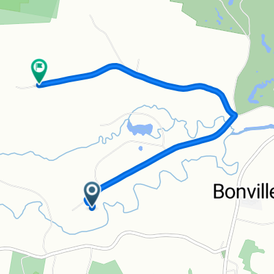
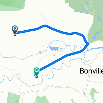
Bongil Bongil Nartional Park has a whole network of dirt roads and trails that we had never explored. This route was just a taster.
We parked the car on Pine creek way and set off down Overhead bridge forest road. We continued along this road past the gate preventing motorised traffic from going further. The map shows two tracks, the Western peninsula trail the Eastern peninsula trail. Of these the former was very overgrown and not readily rideable. However the Eastern trail was easy going with only a few sticks to watch out for. At the end of the fire trail a single track mountain bike trail leads off through the scrub towards the beach. We were able to ride this most of the way before the sand became a bit tedious for our touring bikes and we dumped them (and the gps device) and walked the last bit of the path through to the beach. Here we discovered that it is signposted so it would be possible to find the path from the beach, very useful if trying to find the path from a ride along the beach.
- -:--
- Duration
- 21.1 km
- Distance
- 123 m
- Ascent
- 123 m
- Descent
- ---
- Avg. speed
- ---
- Max. altitude

Route photos


Continue with Bikemap
Use, edit, or download this cycling route
You would like to ride Bongil Bongil National Park explore or customize it for your own trip? Here is what you can do with this Bikemap route:
Free features
- Save this route as favorite or in collections
- Copy & plan your own version of this route
- Sync your route with Garmin or Wahoo
Premium features
Free trial for 3 days, or one-time payment. More about Bikemap Premium.
- Navigate this route on iOS & Android
- Export a GPX / KML file of this route
- Create your custom printout (try it for free)
- Download this route for offline navigation
Discover more Premium features.
Get Bikemap PremiumFrom our community
Other popular routes starting in Bonville
 Annie to home
- Distance
- 5 km
- Ascent
- 47 m
- Descent
- 66 m
- Location
- Bonville, New South Wales, Australia
 Coffs 2 day 2nd day
- Distance
- 13.3 km
- Ascent
- 175 m
- Descent
- 172 m
- Location
- Bonville, New South Wales, Australia
 10–18 George Street, Mylestom to 23-35 Bowra Street, Urunga
- Distance
- 12.7 km
- Ascent
- 93 m
- Descent
- 90 m
- Location
- Bonville, New South Wales, Australia
 51–53 Butlers Rd, Bonville to 345 Pacific Highway, Coffs Harbour
- Distance
- 13.9 km
- Ascent
- 141 m
- Descent
- 155 m
- Location
- Bonville, New South Wales, Australia
 Route from 50 Keoghs Road, Bonville
- Distance
- 13.7 km
- Ascent
- 179 m
- Descent
- 181 m
- Location
- Bonville, New South Wales, Australia
 Annie's
- Distance
- 5.2 km
- Ascent
- 61 m
- Descent
- 102 m
- Location
- Bonville, New South Wales, Australia
 Bellingen Tandem Ride
- Distance
- 14.7 km
- Ascent
- 257 m
- Descent
- 252 m
- Location
- Bonville, New South Wales, Australia

Edge1000®
Bonville Cycling- Distance
- 16.6 km
- Ascent
- 32 m
- Descent
- 33 m
- Location
- Bonville, New South Wales, Australia
Open it in the app