
Paseo lento en
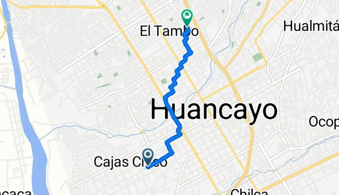
A cycling route starting in El Tambo, Junín Region, Peru.
Overview
About this route
- 15 min
- Duration
- 3.1 km
- Distance
- 52 m
- Ascent
- 15 m
- Descent
- 12.6 km/h
- Avg. speed
- ---
- Max. altitude

Continue with Bikemap
Use, edit, or download this cycling route
You would like to ride Paseo lento en or customize it for your own trip? Here is what you can do with this Bikemap route:
Free features
- Save this route as favorite or in collections
- Copy & plan your own version of this route
- Sync your route with Garmin or Wahoo
Premium features
Free trial for 3 days, or one-time payment. More about Bikemap Premium.
- Navigate this route on iOS & Android
- Export a GPX / KML file of this route
- Create your custom printout (try it for free)
- Download this route for offline navigation
Discover more Premium features.
Get Bikemap PremiumFrom our community
Other popular routes starting in El Tambo
 Jiron Santa Rosa 1446 to Jiron Almirante Miguel Grau 503, Chongos Bajo
- Distance
- 12.9 km
- Ascent
- 212 m
- Descent
- 167 m
- Location
- El Tambo, Junín Region, Peru
 De Jiron Loreto 956, Huancayo a Avenida Huancavelica 488, Huancayo
- Distance
- 0.1 km
- Ascent
- 3 m
- Descent
- 0 m
- Location
- El Tambo, Junín Region, Peru
 Huancayo - Ayacucho
- Distance
- 260.5 km
- Ascent
- 2,317 m
- Descent
- 2,819 m
- Location
- El Tambo, Junín Region, Peru
 r066 ROAM
- Distance
- 133.1 km
- Ascent
- 594 m
- Descent
- 138 m
- Location
- El Tambo, Junín Region, Peru
 Ayak1
Ayak1- Distance
- 194.6 km
- Ascent
- 1,440 m
- Descent
- 2,494 m
- Location
- El Tambo, Junín Region, Peru
 De Jirón Moquegua 230 a Moquegua 220, Huancayo
- Distance
- 20.5 km
- Ascent
- 273 m
- Descent
- 273 m
- Location
- El Tambo, Junín Region, Peru
 De Junin, Huancayo a Jirón Cuzco, Huancayo
- Distance
- 51.3 km
- Ascent
- 778 m
- Descent
- 779 m
- Location
- El Tambo, Junín Region, Peru
 Huancayo - Quichuas
- Distance
- 110.3 km
- Ascent
- 1,098 m
- Descent
- 1,656 m
- Location
- El Tambo, Junín Region, Peru
Open it in the app