

SOURCES DE L'ESCAUT
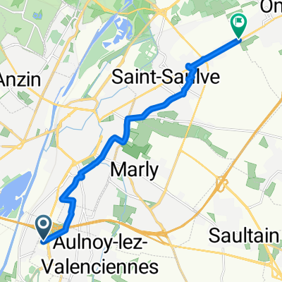
A cycling route starting in Aulnoy-lez-Valenciennes, Hauts-de-France, France.
Overview
About this route
- -:--
- Duration
- 115.8 km
- Distance
- 363 m
- Ascent
- 347 m
- Descent
- ---
- Avg. speed
- ---
- Max. altitude
Route quality
Waytypes & surfaces along the route
Waytypes
Road
64 km
(55 %)
Busy road
29 km
(25 %)
Surfaces
Paved
43.4 km
(37 %)
Unpaved
1.3 km
(1 %)
Asphalt
42.9 km
(37 %)
Gravel
1.2 km
(1 %)
Route highlights
Points of interest along the route
Point of interest after 51.8 km
Source de l' Escaut
Continue with Bikemap
Use, edit, or download this cycling route
You would like to ride SOURCES DE L'ESCAUT or customize it for your own trip? Here is what you can do with this Bikemap route:
Free features
- Save this route as favorite or in collections
- Copy & plan your own version of this route
- Split it into stages to create a multi-day tour
- Sync your route with Garmin or Wahoo
Premium features
Free trial for 3 days, or one-time payment. More about Bikemap Premium.
- Navigate this route on iOS & Android
- Export a GPX / KML file of this route
- Create your custom printout (try it for free)
- Download this route for offline navigation
Discover more Premium features.
Get Bikemap PremiumFrom our community
Other popular routes starting in Aulnoy-lez-Valenciennes
 De Rue Paul Langevin 14, Aulnoy-Lez-Valenciennes à Avenue de la Liberation du 4 Septembre 1944 60, Aulnoy-Lez-Valenciennes
- Distance
- 61 km
- Ascent
- 550 m
- Descent
- 549 m
- Location
- Aulnoy-lez-Valenciennes, Hauts-de-France, France
 Parc d'Activités Jules Mousseron, Aulnoy-lez-Valenciennes à Rue Jean Jaurès, Onnaing
- Distance
- 9.2 km
- Ascent
- 42 m
- Descent
- 83 m
- Location
- Aulnoy-lez-Valenciennes, Hauts-de-France, France
 tour vers Bavay
- Distance
- 62.5 km
- Ascent
- 409 m
- Descent
- 409 m
- Location
- Aulnoy-lez-Valenciennes, Hauts-de-France, France
 128–132 Route d'Aulnoy, Marly à 61 Route d'Aulnoy, Marly
- Distance
- 40.6 km
- Ascent
- 467 m
- Descent
- 471 m
- Location
- Aulnoy-lez-Valenciennes, Hauts-de-France, France
 67 Route d'Aulnoy, Marly à 124 Route d'Aulnoy, Marly
- Distance
- 41.6 km
- Ascent
- 897 m
- Descent
- 899 m
- Location
- Aulnoy-lez-Valenciennes, Hauts-de-France, France
 De 1 Rue du Dauphiné, Valenciennes à 17 Rue Jean Jaurès, Saultain
- Distance
- 5.7 km
- Ascent
- 34 m
- Descent
- 23 m
- Location
- Aulnoy-lez-Valenciennes, Hauts-de-France, France
 avec toff
- Distance
- 35.5 km
- Ascent
- 230 m
- Descent
- 230 m
- Location
- Aulnoy-lez-Valenciennes, Hauts-de-France, France
 De Rue Léon Blum 11, Aulnoy-Lez-Valenciennes à Avenue de la Liberation du 4 Septembre 1944 60, Aulnoy-Lez-Valenciennes
- Distance
- 58.1 km
- Ascent
- 354 m
- Descent
- 340 m
- Location
- Aulnoy-lez-Valenciennes, Hauts-de-France, France
Open it in the app