

oberland rheintal passathon
A cycling route starting in Feldkirch, Vorarlberg, Austria.
Overview
About this route
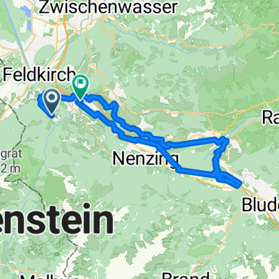
24 Passathon Lighthouses 43 km cycling route ↑ 500 / ↓ 860 meters elevation gain Municipalities: Amerlügen, Feldkirch, Rankweil, Batschuns, Muntlix, Sulz, Röthis, Weiler, Klaus, Götzis, Altach, Mäder
A quarter of a century ago, the first passive houses were built high above Feldkirch. So this tour also starts at Austria's oldest passive house in Amerlügen. The modern Montforthaus event centre impresses as much as several early outstanding renovations of social housing buildings, before climbing steeply again towards the oldest passive house terraced row. Back in the Rhine valley, you will find a variety of municipal buildings with many often heritage-listed renovations, a historic inn, as well as other residential buildings. This tour is also characterised by the outstanding architectural artistry of Vorarlberg.
- -:--
- Duration
- 42.5 km
- Distance
- 460 m
- Ascent
- 819 m
- Descent
- ---
- Avg. speed
- 801 m
- Max. altitude

Route quality
Waytypes & surfaces along the route
Waytypes
Quiet road
27.2 km
(64 %)
Road
3 km
(7 %)
Surfaces
Paved
39.1 km
(92 %)
Unpaved
2.5 km
(6 %)
Asphalt
39.1 km
(92 %)
Gravel
1.7 km
(4 %)
Continue with Bikemap
Use, edit, or download this cycling route
You would like to ride oberland rheintal passathon or customize it for your own trip? Here is what you can do with this Bikemap route:
Free features
- Save this route as favorite or in collections
- Copy & plan your own version of this route
- Sync your route with Garmin or Wahoo
Premium features
Free trial for 3 days, or one-time payment. More about Bikemap Premium.
- Navigate this route on iOS & Android
- Export a GPX / KML file of this route
- Create your custom printout (try it for free)
- Download this route for offline navigation
Discover more Premium features.
Get Bikemap PremiumFrom our community
Other popular routes starting in Feldkirch
 Homeroute of Course
- Distance
- 9.2 km
- Ascent
- 542 m
- Descent
- 542 m
- Location
- Feldkirch, Vorarlberg, Austria
 Frastanz - Tschalengasee
- Distance
- 41.2 km
- Ascent
- 268 m
- Descent
- 588 m
- Location
- Feldkirch, Vorarlberg, Austria
 Bahnhofstraße nach Glöckler
- Distance
- 4.9 km
- Ascent
- 42 m
- Descent
- 61 m
- Location
- Feldkirch, Vorarlberg, Austria
 Stella 2
- Distance
- 6.2 km
- Ascent
- 23 m
- Descent
- 845 m
- Location
- Feldkirch, Vorarlberg, Austria
 App. Achterbahn
- Distance
- 100.7 km
- Ascent
- 1,828 m
- Descent
- 1,489 m
- Location
- Feldkirch, Vorarlberg, Austria
 Runde Gams-Altstätten-Koblach-Feldkirch
- Distance
- 59.3 km
- Ascent
- 394 m
- Descent
- 396 m
- Location
- Feldkirch, Vorarlberg, Austria
 Leonhardsplatz, Feldkirch nach Rheindamm, Gemeinde Gamprin
- Distance
- 10.7 km
- Ascent
- 145 m
- Descent
- 173 m
- Location
- Feldkirch, Vorarlberg, Austria
 2015.08.21. Feldkirch - Landquart Arosa / Mittler hütte (2015 m) - Landquart
- Distance
- 152.1 km
- Ascent
- 1,752 m
- Descent
- 1,659 m
- Location
- Feldkirch, Vorarlberg, Austria
Open it in the app