
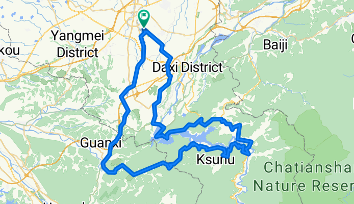
中壢至石門水庫環湖暨羅馬公路
A cycling route starting in Daxi, Taiwan, Taiwan.
Overview
About this route
- -:--
- Duration
- 96.8 km
- Distance
- 1,047 m
- Ascent
- 1,047 m
- Descent
- ---
- Avg. speed
- ---
- Max. altitude
Continue with Bikemap
Use, edit, or download this cycling route
You would like to ride 中壢至石門水庫環湖暨羅馬公路 or customize it for your own trip? Here is what you can do with this Bikemap route:
Free features
- Save this route as favorite or in collections
- Copy & plan your own version of this route
- Split it into stages to create a multi-day tour
- Sync your route with Garmin or Wahoo
Premium features
Free trial for 3 days, or one-time payment. More about Bikemap Premium.
- Navigate this route on iOS & Android
- Export a GPX / KML file of this route
- Create your custom printout (try it for free)
- Download this route for offline navigation
Discover more Premium features.
Get Bikemap PremiumFrom our community
Other popular routes starting in Daxi
 一日雙北
一日雙北- Distance
- 190.3 km
- Ascent
- 8,624 m
- Descent
- 8,424 m
- Location
- Daxi, Taiwan, Taiwan
 忠勇街89巷 to 忠勇街89巷
- Distance
- 23.5 km
- Ascent
- 354 m
- Descent
- 366 m
- Location
- Daxi, Taiwan, Taiwan
 大溪到東眼山
- Distance
- 31.2 km
- Ascent
- 1,041 m
- Descent
- 269 m
- Location
- Daxi, Taiwan, Taiwan
 羅馬公路
羅馬公路- Distance
- 69.6 km
- Ascent
- 2,174 m
- Descent
- 2,097 m
- Location
- Daxi, Taiwan, Taiwan
 羅馬公路
羅馬公路- Distance
- 33.9 km
- Ascent
- 1,239 m
- Descent
- 970 m
- Location
- Daxi, Taiwan, Taiwan
 YUN-忠勇街to 明德路
- Distance
- 35.8 km
- Ascent
- 78 m
- Descent
- 324 m
- Location
- Daxi, Taiwan, Taiwan
 Route to Longtan District
- Distance
- 20.6 km
- Ascent
- 410 m
- Descent
- 556 m
- Location
- Daxi, Taiwan, Taiwan
 三坑老街
三坑老街- Distance
- 22.7 km
- Ascent
- 146 m
- Descent
- 154 m
- Location
- Daxi, Taiwan, Taiwan
Open it in the app