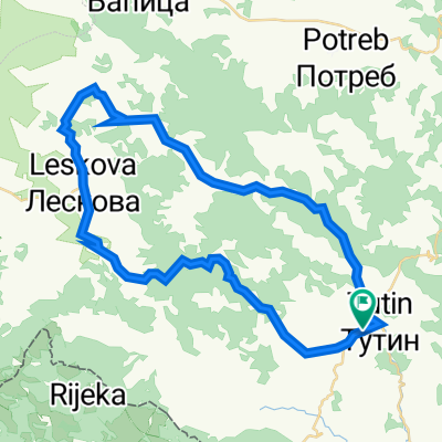
Pešter bike - Ruta: PB 120
A cycling route starting in Tutin, Central Serbia, Serbia.
Overview
About this route
Tutin - Detane - Saš (Crna Gora) - Tutin
- -:--
- Duration
- 24.3 km
- Distance
- 455 m
- Ascent
- 455 m
- Descent
- ---
- Avg. speed
- ---
- Avg. speed
Route quality
Waytypes & surfaces along the route
Waytypes
Quiet road
12.6 km
(52 %)
Busy road
11.8 km
(48 %)
Undefined
0 km
(<1 %)
Surfaces
Paved
5.3 km
(22 %)
Unpaved
11.6 km
(48 %)
Gravel
11.6 km
(48 %)
Asphalt
5.3 km
(22 %)
Undefined
7.4 km
(31 %)
Continue with Bikemap
Use, edit, or download this cycling route
You would like to ride Pešter bike - Ruta: PB 120 or customize it for your own trip? Here is what you can do with this Bikemap route:
Free features
- Save this route as favorite or in collections
- Copy & plan your own version of this route
- Sync your route with Garmin or Wahoo
Premium features
Free trial for 3 days, or one-time payment. More about Bikemap Premium.
- Navigate this route on iOS & Android
- Export a GPX / KML file of this route
- Create your custom printout (try it for free)
- Download this route for offline navigation
Discover more Premium features.
Get Bikemap PremiumFrom our community
Other popular routes starting in Tutin
- Pešter bike - Ruta: PB 118
- Distance
- 9.2 km
- Ascent
- 300 m
- Descent
- 302 m
- Location
- Tutin, Central Serbia, Serbia
- Pešter bike - Ruta: PB 119
- Distance
- 32.4 km
- Ascent
- 1,013 m
- Descent
- 1,013 m
- Location
- Tutin, Central Serbia, Serbia
- Ruta opasna
- Distance
- 41.3 km
- Ascent
- 614 m
- Descent
- 613 m
- Location
- Tutin, Central Serbia, Serbia
- saronjeeee
- Distance
- 13.6 km
- Ascent
- 433 m
- Descent
- 278 m
- Location
- Tutin, Central Serbia, Serbia
- opa123
- Distance
- 3.2 km
- Ascent
- 13 m
- Descent
- 42 m
- Location
- Tutin, Central Serbia, Serbia
- Pešter bike - Ruta: PB 117
- Distance
- 21.8 km
- Ascent
- 186 m
- Descent
- 186 m
- Location
- Tutin, Central Serbia, Serbia
- Pešter bike - Ruta: PB 120
- Distance
- 24.3 km
- Ascent
- 455 m
- Descent
- 455 m
- Location
- Tutin, Central Serbia, Serbia
- Sporty route
- Distance
- 44.8 km
- Ascent
- 217 m
- Descent
- 268 m
- Location
- Tutin, Central Serbia, Serbia
Open it in the app