

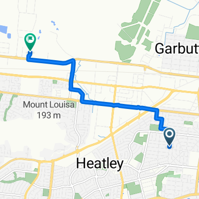
Route to 58 The Strand, North Ward
A cycling route starting in Townsville, Queensland, Australia.
Overview
About this route
- 2 h 13 min
- Duration
- 30.1 km
- Distance
- 4 m
- Ascent
- 10 m
- Descent
- 13.6 km/h
- Avg. speed
- ---
- Max. altitude

Route quality
Waytypes & surfaces along the route
Waytypes
Cycleway
15.7 km
(52 %)
Quiet road
6.9 km
(23 %)
Surfaces
Paved
23.8 km
(79 %)
Unpaved
1.8 km
(6 %)
Concrete
16 km
(53 %)
Asphalt
7.8 km
(26 %)
Continue with Bikemap
Use, edit, or download this cycling route
You would like to ride Route to 58 The Strand, North Ward or customize it for your own trip? Here is what you can do with this Bikemap route:
Free features
- Save this route as favorite or in collections
- Copy & plan your own version of this route
- Sync your route with Garmin or Wahoo
Premium features
Free trial for 3 days, or one-time payment. More about Bikemap Premium.
- Navigate this route on iOS & Android
- Export a GPX / KML file of this route
- Create your custom printout (try it for free)
- Download this route for offline navigation
Discover more Premium features.
Get Bikemap PremiumFrom our community
Other popular routes starting in Townsville
 Boundary Street 12-18, Hermit Park to First Avenue 68, Railway Estate
- Distance
- 57.5 km
- Ascent
- 1,881 m
- Descent
- 1,886 m
- Location
- Townsville, Queensland, Australia
 1 Farrar St, Mundingburra to 53 Oreilly St, Mundingburra
- Distance
- 8.5 km
- Ascent
- 16 m
- Descent
- 16 m
- Location
- Townsville, Queensland, Australia
 Route from 1-19 Snelham Street, Rosslea
- Distance
- 8.7 km
- Ascent
- 3 m
- Descent
- 6 m
- Location
- Townsville, Queensland, Australia
 Route to 2 Admiralty Close, Idalia
- Distance
- 11.1 km
- Ascent
- 0 m
- Descent
- 8 m
- Location
- Townsville, Queensland, Australia
 Townsville to Mt Stewart
- Distance
- 115 km
- Ascent
- 1,254 m
- Descent
- 1,236 m
- Location
- Townsville, Queensland, Australia
 60 Cook Street, North Ward to 60 Cook Street, North Ward
- Distance
- 20.8 km
- Ascent
- 3 m
- Descent
- 3 m
- Location
- Townsville, Queensland, Australia
 Work commute
- Distance
- 10.2 km
- Ascent
- 9 m
- Descent
- 16 m
- Location
- Townsville, Queensland, Australia
 McLean Street 31, Gulliver to Ingham Road 661-671, Mount Saint John
- Distance
- 6.4 km
- Ascent
- 28 m
- Descent
- 34 m
- Location
- Townsville, Queensland, Australia
Open it in the app