

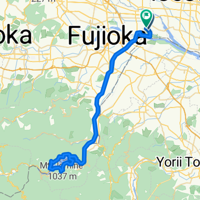
上里歴史巡りルート (上里町ルート)
A cycling route starting in Tamamura, Gunma, Japan.
Overview
About this route
- -:--
- Duration
- 14.3 km
- Distance
- 32 m
- Ascent
- 30 m
- Descent
- ---
- Avg. speed
- ---
- Max. altitude

Route quality
Waytypes & surfaces along the route
Waytypes
Quiet road
7.1 km
(50 %)
Road
5.4 km
(38 %)
Surfaces
Paved
1.3 km
(9 %)
Asphalt
0.9 km
(6 %)
Paved (undefined)
0.4 km
(3 %)
Undefined
13 km
(91 %)
Continue with Bikemap
Use, edit, or download this cycling route
You would like to ride 上里歴史巡りルート (上里町ルート) or customize it for your own trip? Here is what you can do with this Bikemap route:
Free features
- Save this route as favorite or in collections
- Copy & plan your own version of this route
- Sync your route with Garmin or Wahoo
Premium features
Free trial for 3 days, or one-time payment. More about Bikemap Premium.
- Navigate this route on iOS & Android
- Export a GPX / KML file of this route
- Create your custom printout (try it for free)
- Download this route for offline navigation
Discover more Premium features.
Get Bikemap PremiumFrom our community
Other popular routes starting in Tamamura
 広瀬川サイクリングロード
- Distance
- 6.1 km
- Ascent
- 18 m
- Descent
- 26 m
- Location
- Tamamura, Gunma, Japan
 1189-4, Shimoshinden, Tamamura, Sawa-Gun to 国道18号, Annaka
- Distance
- 45.5 km
- Ascent
- 675 m
- Descent
- 146 m
- Location
- Tamamura, Gunma, Japan
 350, Kamiiijima, Tamamura, Sawa-Gun to 351-2, Kamiiijima, Tamamura, Sawa-Gun
- Distance
- 38.7 km
- Ascent
- 355 m
- Descent
- 358 m
- Location
- Tamamura, Gunma, Japan
 1189-4, Shimoshinden, Tamamura, Sawa-Gun to Azumachogodo, Midori
- Distance
- 48.6 km
- Ascent
- 1,085 m
- Descent
- 737 m
- Location
- Tamamura, Gunma, Japan
 210522 敷島公園バラ園
- Distance
- 46.6 km
- Ascent
- 214 m
- Descent
- 214 m
- Location
- Tamamura, Gunma, Japan
 新町2103-26, 高崎市へ児玉町共栄360-1, 本庄市
- Distance
- 11.5 km
- Ascent
- 34 m
- Descent
- 20 m
- Location
- Tamamura, Gunma, Japan
 上里歴史巡りルート (上里町ルート)
- Distance
- 14.3 km
- Ascent
- 32 m
- Descent
- 30 m
- Location
- Tamamura, Gunma, Japan
 Shimomogi, Tamamura to Shimomogi, Tamamura
- Distance
- 65 km
- Ascent
- 774 m
- Descent
- 773 m
- Location
- Tamamura, Gunma, Japan
Open it in the app