
BCM Nowatex
A cycling route starting in Dopiewo, Greater Poland Voivodeship, Poland.
Overview
About this route
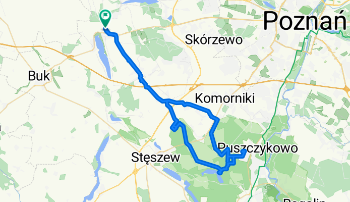
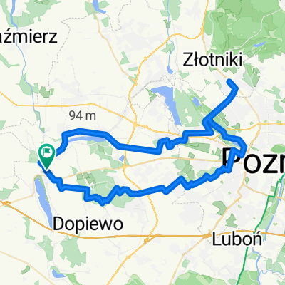
Drwęsa - Dopiewo - Konarzewo - Chomęcice - Rosnowo - Szreniawa - jez.Jarosławieckie - Puszczykowo-Nowatex - jez.Góreckie - Trzebaw - Glinki - Konarzewo - Dopiewo - Drwęsa
- -:--
- Duration
- 57.1 km
- Distance
- 108 m
- Ascent
- 115 m
- Descent
- ---
- Avg. speed
- ---
- Max. altitude

Route quality
Waytypes & surfaces along the route
Waytypes
Quiet road
21.1 km
(37 %)
Road
17.7 km
(31 %)
Surfaces
Paved
27.4 km
(48 %)
Unpaved
10.8 km
(19 %)
Asphalt
26.2 km
(46 %)
Gravel
6.8 km
(12 %)
Continue with Bikemap
Use, edit, or download this cycling route
You would like to ride BCM Nowatex or customize it for your own trip? Here is what you can do with this Bikemap route:
Free features
- Save this route as favorite or in collections
- Copy & plan your own version of this route
- Sync your route with Garmin or Wahoo
Premium features
Free trial for 3 days, or one-time payment. More about Bikemap Premium.
- Navigate this route on iOS & Android
- Export a GPX / KML file of this route
- Create your custom printout (try it for free)
- Download this route for offline navigation
Discover more Premium features.
Get Bikemap PremiumFrom our community
Other popular routes starting in Dopiewo
 Lusowo-Podłoziny
- Distance
- 39.3 km
- Ascent
- 126 m
- Descent
- 136 m
- Location
- Dopiewo, Greater Poland Voivodeship, Poland
 BCM Nowatex
- Distance
- 57.1 km
- Ascent
- 108 m
- Descent
- 115 m
- Location
- Dopiewo, Greater Poland Voivodeship, Poland
 Stęszew + Rybojedzko
- Distance
- 43.7 km
- Ascent
- 85 m
- Descent
- 91 m
- Location
- Dopiewo, Greater Poland Voivodeship, Poland
 Dąbrówka/Szkoła do Różana 2, Palędzie
- Distance
- 27.6 km
- Ascent
- 57 m
- Descent
- 57 m
- Location
- Dopiewo, Greater Poland Voivodeship, Poland
 Suchy Las - 2Koła
- Distance
- 65.1 km
- Ascent
- 90 m
- Descent
- 90 m
- Location
- Dopiewo, Greater Poland Voivodeship, Poland
 Trasa Rodzinna: Dąbrówka - Zborowo
- Distance
- 10 km
- Ascent
- 40 m
- Descent
- 41 m
- Location
- Dopiewo, Greater Poland Voivodeship, Poland
 Szlak Nadwarciański
- Distance
- 100.5 km
- Ascent
- 125 m
- Descent
- 125 m
- Location
- Dopiewo, Greater Poland Voivodeship, Poland
 T - Z - D
- Distance
- 37.7 km
- Ascent
- 90 m
- Descent
- 106 m
- Location
- Dopiewo, Greater Poland Voivodeship, Poland
Open it in the app