

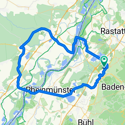
Rote Lache - Badener Höhe - Burg Wineck - Yburg
A cycling route starting in Sinzheim, Baden-Wurttemberg, Germany.
Overview
About this route
- -:--
- Duration
- 64.6 km
- Distance
- 1,307 m
- Ascent
- 1,308 m
- Descent
- ---
- Avg. speed
- ---
- Max. altitude
Route quality
Waytypes & surfaces along the route
Waytypes
Track
24.6 km
(38 %)
Quiet road
14.9 km
(23 %)
Surfaces
Paved
26.5 km
(41 %)
Unpaved
23.9 km
(37 %)
Asphalt
25.2 km
(39 %)
Gravel
18.7 km
(29 %)
Continue with Bikemap
Use, edit, or download this cycling route
You would like to ride Rote Lache - Badener Höhe - Burg Wineck - Yburg or customize it for your own trip? Here is what you can do with this Bikemap route:
Free features
- Save this route as favorite or in collections
- Copy & plan your own version of this route
- Sync your route with Garmin or Wahoo
Premium features
Free trial for 3 days, or one-time payment. More about Bikemap Premium.
- Navigate this route on iOS & Android
- Export a GPX / KML file of this route
- Create your custom printout (try it for free)
- Download this route for offline navigation
Discover more Premium features.
Get Bikemap PremiumFrom our community
Other popular routes starting in Sinzheim
 gemütliche Flachetappe
- Distance
- 62.4 km
- Ascent
- 56 m
- Descent
- 56 m
- Location
- Sinzheim, Baden-Wurttemberg, Germany
 Sinzheim - Rheinmünster I
- Distance
- 48.1 km
- Ascent
- 32 m
- Descent
- 30 m
- Location
- Sinzheim, Baden-Wurttemberg, Germany
 GA1/2 und KA
- Distance
- 35.7 km
- Ascent
- 217 m
- Descent
- 216 m
- Location
- Sinzheim, Baden-Wurttemberg, Germany
 Fremersberg
- Distance
- 9 km
- Ascent
- 395 m
- Descent
- 417 m
- Location
- Sinzheim, Baden-Wurttemberg, Germany
 Sinzheim-Badnerhöhe-Rote Lache-BAD-Sinz
- Distance
- 52.5 km
- Ascent
- 1,054 m
- Descent
- 1,054 m
- Location
- Sinzheim, Baden-Wurttemberg, Germany
 Feierabendtour
- Distance
- 15.2 km
- Ascent
- 599 m
- Descent
- 598 m
- Location
- Sinzheim, Baden-Wurttemberg, Germany
 Rote Lache - Badener Höhe - Burg Wineck - Yburg
- Distance
- 64.6 km
- Ascent
- 1,307 m
- Descent
- 1,308 m
- Location
- Sinzheim, Baden-Wurttemberg, Germany
 Altes Schloss - Merkur - Yburg - Fremersberg
- Distance
- 44.2 km
- Ascent
- 1,176 m
- Descent
- 1,176 m
- Location
- Sinzheim, Baden-Wurttemberg, Germany
Open it in the app