MTB-Tour Küste, Brandung und Berge
A cycling route starting in Playa Blanca, Canary Islands, Spain.
Overview
About this route
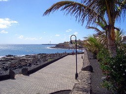
The starting point is the waterfront promenade in Playa Blanca. Along the promenade to the lighthouse, then continue on the promenade through the urbanizations to open terrain, further along the coast on a narrow, not easy to ride surface. A secure riding technique facilitates managing this section of the route. Those who do not want to walk the beach section in front of the saline should take the LZ-701 to the next roundabout. Then a slight climb to Las Brenas and a descent on the LZ-703 towards Playa Blanca. The following climb (km 24.5) on loose gravel requires superb fitness – but it can also be pushed. At the top, you are greeted by goats in a goat pen standing here. The following 5 km downhill is insane, but requires attention. Since the route passes near the Papagayo beaches, a detour there is advisable.
Note: Those who avoid the steep, gravelly climb should do the tour in reverse. The climb to the goat pen is then significantly longer but less demanding.
- -:--
- Duration
- 49.6 km
- Distance
- 545 m
- Ascent
- 552 m
- Descent
- ---
- Avg. speed
- ---
- Max. altitude
Route highlights
Points of interest along the route

Photo after 5.7 km

Photo after 8.6 km

Photo after 14.4 km

Photo after 29.2 km

Photo after 36.5 km

Photo after 39.7 km

Photo after 49.6 km
Continue with Bikemap
Use, edit, or download this cycling route
You would like to ride MTB-Tour Küste, Brandung und Berge or customize it for your own trip? Here is what you can do with this Bikemap route:
Free features
- Save this route as favorite or in collections
- Copy & plan your own version of this route
- Sync your route with Garmin or Wahoo
Premium features
Free trial for 3 days, or one-time payment. More about Bikemap Premium.
- Navigate this route on iOS & Android
- Export a GPX / KML file of this route
- Create your custom printout (try it for free)
- Download this route for offline navigation
Discover more Premium features.
Get Bikemap PremiumFrom our community
Other popular routes starting in Playa Blanca
 Ruta Playa Blanca Timanfaya Lanzarote
- Distance
- 97.5 km
- Ascent
- 962 m
- Descent
- 962 m
- Location
- Playa Blanca, Canary Islands, Spain
 Playa Blanca-El Golfo-Yaiza-El Golfo-Playa Blanca
- Distance
- 51.2 km
- Ascent
- 421 m
- Descent
- 421 m
- Location
- Playa Blanca, Canary Islands, Spain
 Lanzarote Süd 2
- Distance
- 53.2 km
- Ascent
- 498 m
- Descent
- 500 m
- Location
- Playa Blanca, Canary Islands, Spain
 circuit playa blanca
- Distance
- 28.9 km
- Ascent
- 184 m
- Descent
- 187 m
- Location
- Playa Blanca, Canary Islands, Spain
 Lanzarote 1. Volcanes
- Distance
- 87.6 km
- Ascent
- 852 m
- Descent
- 845 m
- Location
- Playa Blanca, Canary Islands, Spain
 Lanzarote / ein bißchen Ironman
- Distance
- 157.4 km
- Ascent
- 1,535 m
- Descent
- 1,537 m
- Location
- Playa Blanca, Canary Islands, Spain
 C.C. Papagayo, Playa Blanca to Calle Monta/a Roja 31, Playa Blanca
- Distance
- 12.3 km
- Ascent
- 41 m
- Descent
- 20 m
- Location
- Playa Blanca, Canary Islands, Spain
 Ironmanradstrecke leicht abgeändert von Playa Blanca aus
- Distance
- 180.3 km
- Ascent
- 1,718 m
- Descent
- 1,718 m
- Location
- Playa Blanca, Canary Islands, Spain
Open it in the app

