
Seniorenfräd 2011 SC 02
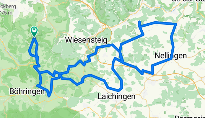
A cycling route starting in Neidlingen, Baden-Wurttemberg, Germany.
Overview
About this route
Steigungsquotient = 9.1 Hm/km
Referenz: Alb Extrem 190 km = 15.8 Hm/km
- -:--
- Duration
- 89.2 km
- Distance
- 589 m
- Ascent
- 589 m
- Descent
- ---
- Avg. speed
- ---
- Max. altitude

Route quality
Waytypes & surfaces along the route
Waytypes
Track
26.3 km
(29 %)
Busy road
21.7 km
(24 %)
Surfaces
Paved
66 km
(74 %)
Unpaved
2 km
(2 %)
Asphalt
57.5 km
(64 %)
Paved (undefined)
8.5 km
(10 %)
Route highlights
Points of interest along the route
Point of interest after 41 km
Gartenwirtschaft Ruine Berneck
Continue with Bikemap
Use, edit, or download this cycling route
You would like to ride Seniorenfräd 2011 SC 02 or customize it for your own trip? Here is what you can do with this Bikemap route:
Free features
- Save this route as favorite or in collections
- Copy & plan your own version of this route
- Split it into stages to create a multi-day tour
- Sync your route with Garmin or Wahoo
Premium features
Free trial for 3 days, or one-time payment. More about Bikemap Premium.
- Navigate this route on iOS & Android
- Export a GPX / KML file of this route
- Create your custom printout (try it for free)
- Download this route for offline navigation
Discover more Premium features.
Get Bikemap PremiumFrom our community
Other popular routes starting in Neidlingen
 3 Albsteigen mit Burg_ST
- Distance
- 67.6 km
- Ascent
- 1,227 m
- Descent
- 1,212 m
- Location
- Neidlingen, Baden-Wurttemberg, Germany
 Seniorenfräd 2011 SC 02
- Distance
- 89.2 km
- Ascent
- 589 m
- Descent
- 589 m
- Location
- Neidlingen, Baden-Wurttemberg, Germany
 Harpprechtshaus
- Distance
- 32.8 km
- Ascent
- 686 m
- Descent
- 686 m
- Location
- Neidlingen, Baden-Wurttemberg, Germany
 Hepsisau-Neidlingen über Michaelshof
- Distance
- 4.9 km
- Ascent
- 238 m
- Descent
- 243 m
- Location
- Neidlingen, Baden-Wurttemberg, Germany
 neidlinger alb
- Distance
- 20.4 km
- Ascent
- 455 m
- Descent
- 459 m
- Location
- Neidlingen, Baden-Wurttemberg, Germany
 Reußenstein-Filstal
- Distance
- 44.6 km
- Ascent
- 159 m
- Descent
- 541 m
- Location
- Neidlingen, Baden-Wurttemberg, Germany
 Neidlingen - Bahnhöfle - Ochsenwang - Breitenstein - Michaelshof - Neidlingen
- Distance
- 18.8 km
- Ascent
- 603 m
- Descent
- 603 m
- Location
- Neidlingen, Baden-Wurttemberg, Germany
 home Schopfloch 2
- Distance
- 30.8 km
- Ascent
- 491 m
- Descent
- 485 m
- Location
- Neidlingen, Baden-Wurttemberg, Germany
Open it in the app