

Saint Jacques
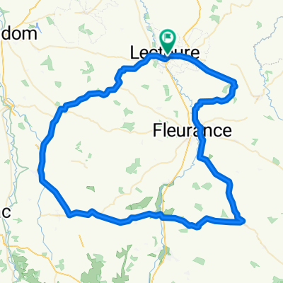
A cycling route starting in Lectoure, Occitanie, France.
Overview
About this route
1st stage Lectoure-Eauze
- -:--
- Duration
- 58.5 km
- Distance
- 522 m
- Ascent
- 528 m
- Descent
- ---
- Avg. speed
- ---
- Max. altitude

Route quality
Waytypes & surfaces along the route
Waytypes
Quiet road
17 km
(29 %)
Cycleway
15.2 km
(26 %)
Surfaces
Paved
36.3 km
(62 %)
Unpaved
2.9 km
(5 %)
Asphalt
35.7 km
(61 %)
Gravel
1.2 km
(2 %)
Continue with Bikemap
Use, edit, or download this cycling route
You would like to ride Saint Jacques or customize it for your own trip? Here is what you can do with this Bikemap route:
Free features
- Save this route as favorite or in collections
- Copy & plan your own version of this route
- Sync your route with Garmin or Wahoo
Premium features
Free trial for 3 days, or one-time payment. More about Bikemap Premium.
- Navigate this route on iOS & Android
- Export a GPX / KML file of this route
- Create your custom printout (try it for free)
- Download this route for offline navigation
Discover more Premium features.
Get Bikemap PremiumFrom our community
Other popular routes starting in Lectoure
 Itinéraire à partir de D166, La Romieu
- Distance
- 5.8 km
- Ascent
- 57 m
- Descent
- 43 m
- Location
- Lectoure, Occitanie, France
 LECTOURE
- Distance
- 86.4 km
- Ascent
- 883 m
- Descent
- 901 m
- Location
- Lectoure, Occitanie, France
 Projet sortie 3
- Distance
- 90.9 km
- Ascent
- 918 m
- Descent
- 915 m
- Location
- Lectoure, Occitanie, France
 Pamplona - Hamburg Tag 06 Lectoure - Moissac
- Distance
- 53.5 km
- Ascent
- 708 m
- Descent
- 811 m
- Location
- Lectoure, Occitanie, France
 Saint Jacques
- Distance
- 58.5 km
- Ascent
- 522 m
- Descent
- 528 m
- Location
- Lectoure, Occitanie, France
 Chemin de Saint-Clair, Lectoure à 1 Boulevard Lacave, La Romieu
- Distance
- 14.1 km
- Ascent
- 250 m
- Descent
- 245 m
- Location
- Lectoure, Occitanie, France
 Isle Bouzon ou Lectoure / Montech
- Distance
- 63 km
- Ascent
- 699 m
- Descent
- 760 m
- Location
- Lectoure, Occitanie, France
 e79b0d42-19e9-4539-bd10-2b44039d62c7
- Distance
- 34.6 km
- Ascent
- 608 m
- Descent
- 685 m
- Location
- Lectoure, Occitanie, France
Open it in the app