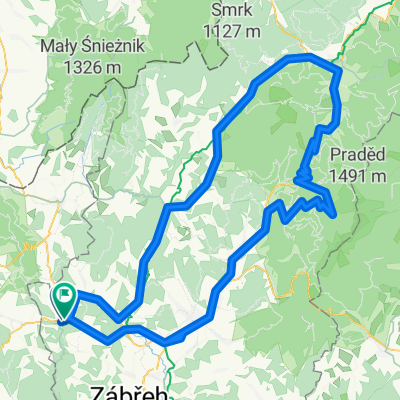
Rampušák 2011 - krátká CLONED FROM ROUTE 797000
A cycling route starting in Štíty, Olomoucký kraj, Czechia.
Overview
About this route
Čím více zde napíšete informací, tím více bude užitečnější pro ostatním uživatele.* Průběh trasy.* Co je zvláštní na této trase?* Proč doporučit tuto trasu?* Co se Vám zde nejvíce líbilo?* Atd.
- -:--
- Duration
- 137.7 km
- Distance
- 1,583 m
- Ascent
- 1,583 m
- Descent
- ---
- Avg. speed
- ---
- Max. altitude
Route quality
Waytypes & surfaces along the route
Waytypes
Busy road
102.7 km
(75 %)
Road
18.9 km
(14 %)
Surfaces
Paved
81.3 km
(59 %)
Unpaved
4.8 km
(3 %)
Asphalt
80.2 km
(58 %)
Ground
2.3 km
(2 %)
Continue with Bikemap
Use, edit, or download this cycling route
You would like to ride Rampušák 2011 - krátká CLONED FROM ROUTE 797000 or customize it for your own trip? Here is what you can do with this Bikemap route:
Free features
- Save this route as favorite or in collections
- Copy & plan your own version of this route
- Split it into stages to create a multi-day tour
- Sync your route with Garmin or Wahoo
Premium features
Free trial for 3 days, or one-time payment. More about Bikemap Premium.
- Navigate this route on iOS & Android
- Export a GPX / KML file of this route
- Create your custom printout (try it for free)
- Download this route for offline navigation
Discover more Premium features.
Get Bikemap PremiumFrom our community
Other popular routes starting in Štíty
- Rampušák 2016 - 120 km
- Distance
- 119.6 km
- Ascent
- 1,292 m
- Descent
- 1,285 m
- Location
- Štíty, Olomoucký kraj, Czechia
- Rampušák 2011 - krátká CLONED FROM ROUTE 797000
- Distance
- 137.7 km
- Ascent
- 1,583 m
- Descent
- 1,583 m
- Location
- Štíty, Olomoucký kraj, Czechia
- Kelly's Rampušák 2012 - Silnice krátká
- Distance
- 139.5 km
- Ascent
- 1,609 m
- Descent
- 1,609 m
- Location
- Štíty, Olomoucký kraj, Czechia
- Kelly's Rampušák 2012 - silnice dlouhá
- Distance
- 179.2 km
- Ascent
- 2,102 m
- Descent
- 2,101 m
- Location
- Štíty, Olomoucký kraj, Czechia
- Štíty - Heroltice - Č. Voda - M. Karlov - Severomoravská chata - Hedeč - Králíky - Boříkovice - Č. Voda - Březná - Štíty
- Distance
- 50.4 km
- Ascent
- 508 m
- Descent
- 507 m
- Location
- Štíty, Olomoucký kraj, Czechia
- Rampušák 2015 - 120 km
- Distance
- 119.6 km
- Ascent
- 1,294 m
- Descent
- 1,287 m
- Location
- Štíty, Olomoucký kraj, Czechia
- Rampušák 2014 130 km
- Distance
- 127.2 km
- Ascent
- 1,529 m
- Descent
- 1,529 m
- Location
- Štíty, Olomoucký kraj, Czechia
- Rampušák dlouhá 2013
- Distance
- 165.5 km
- Ascent
- 1,851 m
- Descent
- 1,853 m
- Location
- Štíty, Olomoucký kraj, Czechia
Open it in the app