
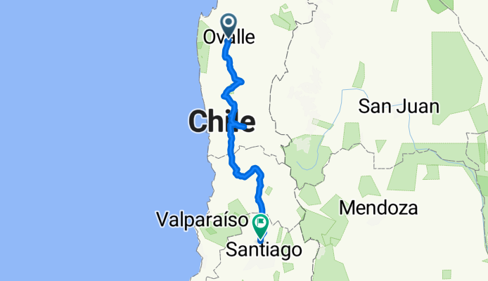
:Ovalle Punitaqui Combarbala, Salamanca, Cabildo, Putaendo, Santiago
A cycling route starting in Ovalle, Coquimbo Region, Chile.
Overview
About this route
Extremely demanding route, featuring an 11 km stretch of dirt and sand climbing starting from Punitaqui. From there to Combarbalá, the surface is oily dirt. From Limahuida to the Las Palmas tunnel, it's pure gravel and sand with three 10 km climbs plus the Las Astas, Recto, Curvo, Las Palmas tunnels, with the latter containing water inside. The La Grupa tunnel has a traffic light to indicate the direction of the small transit (6 minutes per side). It is an extreme, dangerous, and purely adventurous route. Completed in 2009.
- -:--
- Duration
- 457.4 km
- Distance
- 4,403 m
- Ascent
- 4,097 m
- Descent
- ---
- Avg. speed
- ---
- Max. altitude

Continue with Bikemap
Use, edit, or download this cycling route
You would like to ride :Ovalle Punitaqui Combarbala, Salamanca, Cabildo, Putaendo, Santiago or customize it for your own trip? Here is what you can do with this Bikemap route:
Free features
- Save this route as favorite or in collections
- Copy & plan your own version of this route
- Split it into stages to create a multi-day tour
- Sync your route with Garmin or Wahoo
Premium features
Free trial for 3 days, or one-time payment. More about Bikemap Premium.
- Navigate this route on iOS & Android
- Export a GPX / KML file of this route
- Create your custom printout (try it for free)
- Download this route for offline navigation
Discover more Premium features.
Get Bikemap PremiumFrom our community
Other popular routes starting in Ovalle
 Vuelta corta por Talhuén
- Distance
- 47.8 km
- Ascent
- 348 m
- Descent
- 348 m
- Location
- Ovalle, Coquimbo Region, Chile
 San Julián - Punitaqui
- Distance
- 53 km
- Ascent
- 314 m
- Descent
- 319 m
- Location
- Ovalle, Coquimbo Region, Chile
 Alberto Blest Gana 1744–1790, Ovalle a María Inés Corral Garrido 656, Ovalle
- Distance
- 5.6 km
- Ascent
- 6 m
- Descent
- 6 m
- Location
- Ovalle, Coquimbo Region, Chile
 San Julián - El Espinal - Socos
- Distance
- 57.7 km
- Ascent
- 442 m
- Descent
- 455 m
- Location
- Ovalle, Coquimbo Region, Chile
 San Julián - Talhuén - Limarí
- Distance
- 33 km
- Ascent
- 268 m
- Descent
- 271 m
- Location
- Ovalle, Coquimbo Region, Chile
 Ruta covid19 ovalle huamalata
- Distance
- 41.8 km
- Ascent
- 481 m
- Descent
- 500 m
- Location
- Ovalle, Coquimbo Region, Chile
 ovalle talhuen, costanera
- Distance
- 31.3 km
- Ascent
- 327 m
- Descent
- 331 m
- Location
- Ovalle, Coquimbo Region, Chile
 San Julián - El Divisadero - Altar - Potrerillos Alto
- Distance
- 79.1 km
- Ascent
- 880 m
- Descent
- 880 m
- Location
- Ovalle, Coquimbo Region, Chile
Open it in the app