

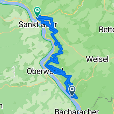
Rheinsteig 07. Etappe Kaub - St. Goarshausen (Süd-Nord)
A cycling route starting in Kaub, Rhineland-Palatinate, Germany.
Overview
About this route
Kaub - Dörscheid - Rossstein - Alte Burg - Urbachtal - Waldschule - Bornichbachtal - Fünf Seenplatz - Spitznack - Loreley - Heide - St. Goarshausen - Dreiburgenblick - Hasenbachtal
- -:--
- Duration
- 21.5 km
- Distance
- 929 m
- Ascent
- 934 m
- Descent
- ---
- Avg. speed
- ---
- Max. altitude
Route quality
Waytypes & surfaces along the route
Waytypes
Path
8.6 km
(40 %)
Track
7.3 km
(34 %)
Surfaces
Paved
4.1 km
(19 %)
Unpaved
13.8 km
(64 %)
Ground
7.1 km
(33 %)
Gravel
5.6 km
(26 %)
Continue with Bikemap
Use, edit, or download this cycling route
You would like to ride Rheinsteig 07. Etappe Kaub - St. Goarshausen (Süd-Nord) or customize it for your own trip? Here is what you can do with this Bikemap route:
Free features
- Save this route as favorite or in collections
- Copy & plan your own version of this route
- Sync your route with Garmin or Wahoo
Premium features
Free trial for 3 days, or one-time payment. More about Bikemap Premium.
- Navigate this route on iOS & Android
- Export a GPX / KML file of this route
- Create your custom printout (try it for free)
- Download this route for offline navigation
Discover more Premium features.
Get Bikemap PremiumFrom our community
Other popular routes starting in Kaub
 Morgenbachtal
- Distance
- 48 km
- Ascent
- 774 m
- Descent
- 775 m
- Location
- Kaub, Rhineland-Palatinate, Germany
 Zollstraße naar Nastätter Straße
- Distance
- 41.3 km
- Ascent
- 2,087 m
- Descent
- 2,086 m
- Location
- Kaub, Rhineland-Palatinate, Germany
 Dickies Loreley Rundfahrt
- Distance
- 56.6 km
- Ascent
- 417 m
- Descent
- 417 m
- Location
- Kaub, Rhineland-Palatinate, Germany
 Etape 22: Kaub - Koblenz
- Distance
- 47.6 km
- Ascent
- 269 m
- Descent
- 280 m
- Location
- Kaub, Rhineland-Palatinate, Germany
 Etappe 2
- Distance
- 10 km
- Ascent
- 227 m
- Descent
- 258 m
- Location
- Kaub, Rhineland-Palatinate, Germany
 Von Mannheim bis
- Distance
- 116.3 km
- Ascent
- 918 m
- Descent
- 941 m
- Location
- Kaub, Rhineland-Palatinate, Germany
 18_Zur Loreley
- Distance
- 19.8 km
- Ascent
- 649 m
- Descent
- 645 m
- Location
- Kaub, Rhineland-Palatinate, Germany
 Touristisches Angebot - developed - 072: Oberwesel – Bingen am Rhein (DEVELOPED)
- Distance
- 194 km
- Ascent
- 973 m
- Descent
- 886 m
- Location
- Kaub, Rhineland-Palatinate, Germany
Open it in the app