

York to Tadcaster Circular
A cycling route starting in York, England, United Kingdom.
Overview
About this route
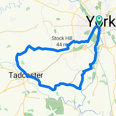
Starting at the York Millennium Bridge, the route follows Sustrans Route 65 to Bishopthorpe then joins the minor roads through Acaster Malbis, Appleton Roebuck, Bolton Percy, Oxton to the Roman town of Tadcaster. Good food at Tykes Tea Rooms on the main street, (next door to an excellent cycle shop). The return routeLeaves Tadcaster alongside the A64 for a very short distance then turns left to Catterton, Bilbrough, Askham Bryan, alongside the A64 for a mile or so then back onto Route 65 back to the start. A very flat route. Bolton Percy has a lovely church with a beautiful stained glass window where you can spend some time discovering all sorts within the window. Suitable for any roadworthy bike.
- -:--
- Duration
- 42 km
- Distance
- 72 m
- Ascent
- 72 m
- Descent
- ---
- Avg. speed
- ---
- Max. altitude
Route quality
Waytypes & surfaces along the route
Waytypes
Road
11.8 km
(28 %)
Quiet road
10.5 km
(25 %)
Surfaces
Paved
20.5 km
(49 %)
Unpaved
3.1 km
(7 %)
Asphalt
19.5 km
(47 %)
Unpaved (undefined)
1.7 km
(4 %)
Continue with Bikemap
Use, edit, or download this cycling route
You would like to ride York to Tadcaster Circular or customize it for your own trip? Here is what you can do with this Bikemap route:
Free features
- Save this route as favorite or in collections
- Copy & plan your own version of this route
- Sync your route with Garmin or Wahoo
Premium features
Free trial for 3 days, or one-time payment. More about Bikemap Premium.
- Navigate this route on iOS & Android
- Export a GPX / KML file of this route
- Create your custom printout (try it for free)
- Download this route for offline navigation
Discover more Premium features.
Get Bikemap PremiumFrom our community
Other popular routes starting in York
 Yorkshire
- Distance
- 243.3 km
- Ascent
- 886 m
- Descent
- 784 m
- Location
- York, England, United Kingdom
 The Southern Loop
- Distance
- 43.2 km
- Ascent
- 72 m
- Descent
- 72 m
- Location
- York, England, United Kingdom
 York - Westow - York
- Distance
- 64.9 km
- Ascent
- 118 m
- Descent
- 114 m
- Location
- York, England, United Kingdom
 Fridaythorpe (Pockington) 2018-12-19
- Distance
- 84 km
- Ascent
- 395 m
- Descent
- 391 m
- Location
- York, England, United Kingdom
 York - Crayke - York via Easingwold
- Distance
- 63.9 km
- Ascent
- 117 m
- Descent
- 115 m
- Location
- York, England, United Kingdom
 Tockwith Spotted Ox
- Distance
- 54.1 km
- Ascent
- 115 m
- Descent
- 110 m
- Location
- York, England, United Kingdom
 37 Monkgate, York to 33 Huntington Road, York
- Distance
- 16.1 km
- Ascent
- 6 m
- Descent
- 13 m
- Location
- York, England, United Kingdom
 Beningborough short loop
- Distance
- 29.3 km
- Ascent
- 43 m
- Descent
- 44 m
- Location
- York, England, United Kingdom
Open it in the app