Pergamino, Benítez, Acevedo, Peña.
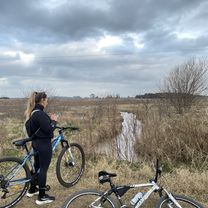
A cycling route starting in Pergamino, Buenos Aires, Argentina.
Overview
About this route
<div style="background-image: initial; background-attachment: initial; background-origin: initial; background-clip: initial; background-color: #ffffff; color: #535353; font-family: Verdana, Arial, Helvetica, sans-serif; font-size: 10px; margin: 8px;">
70 km. RuralBike pasando por el monolito histórico de la Batalla de Cepeda a la vera del arroyo homónimo y volviendo a Pergamino por Acevedo y Peña. </div>
- -:--
- Duration
- 66.9 km
- Distance
- 72 m
- Ascent
- 72 m
- Descent
- ---
- Avg. speed
- ---
- Max. altitude
Route quality
Waytypes & surfaces along the route
Waytypes
Quiet road
34.9 km
(52 %)
Road
23.1 km
(35 %)
Surfaces
Paved
8.9 km
(13 %)
Unpaved
44.2 km
(66 %)
Unpaved (undefined)
42.7 km
(64 %)
Paved (undefined)
4.8 km
(7 %)
Continue with Bikemap
Use, edit, or download this cycling route
You would like to ride Pergamino, Benítez, Acevedo, Peña. or customize it for your own trip? Here is what you can do with this Bikemap route:
Free features
- Save this route as favorite or in collections
- Copy & plan your own version of this route
- Sync your route with Garmin or Wahoo
Premium features
Free trial for 3 days, or one-time payment. More about Bikemap Premium.
- Navigate this route on iOS & Android
- Export a GPX / KML file of this route
- Create your custom printout (try it for free)
- Download this route for offline navigation
Discover more Premium features.
Get Bikemap PremiumFrom our community
Other popular routes starting in Pergamino
- 17 km por RN8 hasta llegar a pergamino CLONED FROM ROUTE 1939066
- Distance
- 16.1 km
- Ascent
- 60 m
- Descent
- 67 m
- Location
- Pergamino, Buenos Aires, Argentina
- Ecuador, Pergamino a Los Dinosaurios, Pergamino
- Distance
- 19.5 km
- Ascent
- 75 m
- Descent
- 73 m
- Location
- Pergamino, Buenos Aires, Argentina
- Boulevard Rocha, Pergamino a Boulevard Vélez Sarsfield, Pergamino
- Distance
- 24.1 km
- Ascent
- 57 m
- Descent
- 56 m
- Location
- Pergamino, Buenos Aires, Argentina
- Pergamino, Benítez, Acevedo, Peña.
- Distance
- 66.9 km
- Ascent
- 72 m
- Descent
- 72 m
- Location
- Pergamino, Buenos Aires, Argentina
- Pergamino-Urquiza
- Distance
- 40.5 km
- Ascent
- 36 m
- Descent
- 36 m
- Location
- Pergamino, Buenos Aires, Argentina
- ruta 32 pergamino salto
- Distance
- 62.9 km
- Ascent
- 77 m
- Descent
- 95 m
- Location
- Pergamino, Buenos Aires, Argentina
- amansando
- Distance
- 16.3 km
- Ascent
- 28 m
- Descent
- 17 m
- Location
- Pergamino, Buenos Aires, Argentina
- Pellegrini hasta la autopista
- Distance
- 15.2 km
- Ascent
- 53 m
- Descent
- 51 m
- Location
- Pergamino, Buenos Aires, Argentina
Open it in the app