

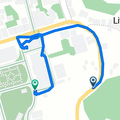
Daang Maharlika Highway, Catbalogan City to Borongan-Guiuan Road, Sulat
A cycling route starting in Catbalogan, Region VIII, Philippines.
Overview
About this route
- 2 h 10 min
- Duration
- 95.8 km
- Distance
- 715 m
- Ascent
- 832 m
- Descent
- 44.2 km/h
- Avg. speed
- ---
- Max. altitude

Route quality
Waytypes & surfaces along the route
Waytypes
Cycleway
20.1 km
(21 %)
Quiet road
2.9 km
(3 %)
Surfaces
Paved
84.3 km
(88 %)
Paved (undefined)
33.5 km
(35 %)
Asphalt
33.5 km
(35 %)
Continue with Bikemap
Use, edit, or download this cycling route
You would like to ride Daang Maharlika Highway, Catbalogan City to Borongan-Guiuan Road, Sulat or customize it for your own trip? Here is what you can do with this Bikemap route:
Free features
- Save this route as favorite or in collections
- Copy & plan your own version of this route
- Split it into stages to create a multi-day tour
- Sync your route with Garmin or Wahoo
Premium features
Free trial for 3 days, or one-time payment. More about Bikemap Premium.
- Navigate this route on iOS & Android
- Export a GPX / KML file of this route
- Create your custom printout (try it for free)
- Download this route for offline navigation
Discover more Premium features.
Get Bikemap PremiumFrom our community
Other popular routes starting in Catbalogan
 Catbalogan-Lagundi-Cawayan-StoNino
- Distance
- 10.2 km
- Ascent
- 366 m
- Descent
- 370 m
- Location
- Catbalogan, Region VIII, Philippines
 Mabini Avenue, Catbalogan City to Daang Maharlika Highway, Tarangnan
- Distance
- 22.3 km
- Ascent
- 47 m
- Descent
- 48 m
- Location
- Catbalogan, Region VIII, Philippines
 Route from Daang Maharlika Highway, Catbalogan City
- Distance
- 0.6 km
- Ascent
- 0 m
- Descent
- 26 m
- Location
- Catbalogan, Region VIII, Philippines
 Catba-Parina
- Distance
- 16.6 km
- Ascent
- 110 m
- Descent
- 170 m
- Location
- Catbalogan, Region VIII, Philippines
 Guinsorongan-Bunuanan Road, Catbalogan City to Guinsorongan-Bunuanan Road, Catbalogan City
- Distance
- 5.7 km
- Ascent
- 115 m
- Descent
- 65 m
- Location
- Catbalogan, Region VIII, Philippines
 Route to Daang Maharlika Highway, Tarangnan
- Distance
- 20.7 km
- Ascent
- 0 m
- Descent
- 6 m
- Location
- Catbalogan, Region VIII, Philippines
 Mahayag
- Distance
- 19.1 km
- Ascent
- 0 m
- Descent
- 5 m
- Location
- Catbalogan, Region VIII, Philippines
 J16 - vendredi 25 janvier 2019 – Catbalogan (Samar) – Tacloban (Leyte)
- Distance
- 108.3 km
- Ascent
- 446 m
- Descent
- 447 m
- Location
- Catbalogan, Region VIII, Philippines
Open it in the app