モシリ サイクリングコース
A cycling route starting in Asahikawa, Hokkaido, Japan.
Overview
About this route
- -:--
- Duration
- 94.1 km
- Distance
- 393 m
- Ascent
- 394 m
- Descent
- ---
- Avg. speed
- ---
- Avg. speed
Continue with Bikemap
Use, edit, or download this cycling route
You would like to ride モシリ サイクリングコース or customize it for your own trip? Here is what you can do with this Bikemap route:
Free features
- Save this route as favorite or in collections
- Copy & plan your own version of this route
- Split it into stages to create a multi-day tour
- Sync your route with Garmin or Wahoo
Premium features
Free trial for 3 days, or one-time payment. More about Bikemap Premium.
- Navigate this route on iOS & Android
- Export a GPX / KML file of this route
- Create your custom printout (try it for free)
- Download this route for offline navigation
Discover more Premium features.
Get Bikemap PremiumFrom our community
Other popular routes starting in Asahikawa
- Dia 18 Asahikawa - Camping Forest Park
- Distance
- 62.5 km
- Ascent
- 447 m
- Descent
- 471 m
- Location
- Asahikawa, Hokkaido, Japan
- asahikawa to biei
- Distance
- 25.9 km
- Ascent
- 276 m
- Descent
- 143 m
- Location
- Asahikawa, Hokkaido, Japan
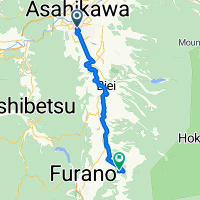
- 2019/8/5 Evening Ride
- Distance
- 24.4 km
- Ascent
- 267 m
- Descent
- 281 m
- Location
- Asahikawa, Hokkaido, Japan
- Lengthy bike tour from 旭川市 to 富良野市
- Distance
- 65.7 km
- Ascent
- 368 m
- Descent
- 214 m
- Location
- Asahikawa, Hokkaido, Japan
- 2019/8/2 Tawaramappu
- Distance
- 25.8 km
- Ascent
- 305 m
- Descent
- 136 m
- Location
- Asahikawa, Hokkaido, Japan
- Dia 17 Shumarinaikohan - Asahikawa
- Distance
- 79.3 km
- Ascent
- 486 m
- Descent
- 634 m
- Location
- Asahikawa, Hokkaido, Japan
- モシリ サイクリングコース
- Distance
- 94.1 km
- Ascent
- 393 m
- Descent
- 394 m
- Location
- Asahikawa, Hokkaido, Japan
- Japan 2013, Day7, Asahikawa - Furen
- Distance
- 96.4 km
- Ascent
- 707 m
- Descent
- 704 m
- Location
- Asahikawa, Hokkaido, Japan
Open it in the app