F100N423Elberadweg Tag 1 und Tag 2 und weitere
A cycling route starting in Rathmannsdorf, Saxony, Germany.
Overview
About this route
Besichtigung Elbsandsteingebirge
Übernachtung in JHB Pirna Tag 2 Weiterfahrt nach Dresden Übernachtung in Radebeul JHB Weiterfahrt nach Wittenberg Übernachtung JHB Ende der Tour - -:--
- Duration
- 423.4 km
- Distance
- 165 m
- Ascent
- 223 m
- Descent
- ---
- Avg. speed
- ---
- Avg. speed
Route quality
Waytypes & surfaces along the route
Waytypes
Busy road
164.2 km
(39 %)
Road
99.2 km
(23 %)
Surfaces
Paved
353.6 km
(84 %)
Unpaved
12.5 km
(3 %)
Asphalt
318.8 km
(75 %)
Paving stones
30.1 km
(7 %)
Continue with Bikemap
Use, edit, or download this cycling route
You would like to ride F100N423Elberadweg Tag 1 und Tag 2 und weitere or customize it for your own trip? Here is what you can do with this Bikemap route:
Free features
- Save this route as favorite or in collections
- Copy & plan your own version of this route
- Sync your route with Garmin or Wahoo
Premium features
Free trial for 3 days, or one-time payment. More about Bikemap Premium.
- Navigate this route on iOS & Android
- Export a GPX / KML file of this route
- Create your custom printout (try it for free)
- Download this route for offline navigation
Discover more Premium features.
Get Bikemap PremiumFrom our community
Other popular routes starting in Rathmannsdorf
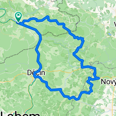
- schöne Trail-Runde über Bastei-Wehlen-Lilienstein
- Distance
- 49.5 km
- Ascent
- 633 m
- Descent
- 633 m
- Location
- Rathmannsdorf, Saxony, Germany
- Bad Schandau - Schneeberg - (Großer Zirnstein) - Schöna - Bad Schandau
- Distance
- 56.2 km
- Ascent
- 909 m
- Descent
- 911 m
- Location
- Rathmannsdorf, Saxony, Germany
- Etappe 9: Bad Schandau - Dresden
- Distance
- 43.8 km
- Ascent
- 103 m
- Descent
- 108 m
- Location
- Rathmannsdorf, Saxony, Germany
- Elbe-Radweg: Bad Schandau - Dresden
- Distance
- 44 km
- Ascent
- 277 m
- Descent
- 287 m
- Location
- Rathmannsdorf, Saxony, Germany
- Grenzfahrt(en)
- Distance
- 48.3 km
- Ascent
- 966 m
- Descent
- 959 m
- Location
- Rathmannsdorf, Saxony, Germany
- Bad Schandau-Zeughaus-Mezni Louka-Schmilka-Bad Schandau
- Distance
- 46.8 km
- Ascent
- 526 m
- Descent
- 526 m
- Location
- Rathmannsdorf, Saxony, Germany
- Hoher Schneeberg (Děčínský Sněžník)
- Distance
- 62.6 km
- Ascent
- 774 m
- Descent
- 774 m
- Location
- Rathmannsdorf, Saxony, Germany
- Bad Schandau - DD - Bad Schandau
- Distance
- 46.9 km
- Ascent
- 369 m
- Descent
- 384 m
- Location
- Rathmannsdorf, Saxony, Germany
Open it in the app