
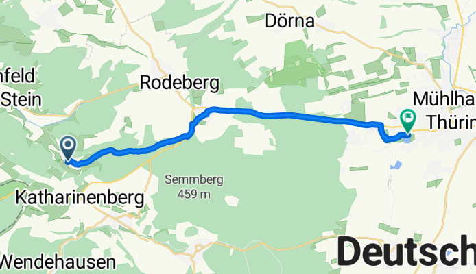
Lindenufer 6, Südeichsfeld nach Schwanenteichallee 45, Mühlhausen/Thüringen
A cycling route starting in Katharinenberg, Free State of Thuringia, Germany.
Overview
About this route
- 48 min
- Duration
- 13.6 km
- Distance
- 190 m
- Ascent
- 289 m
- Descent
- 17.2 km/h
- Avg. speed
- ---
- Avg. speed
Route quality
Waytypes & surfaces along the route
Waytypes
Quiet road
5.6 km
(41 %)
Busy road
5.5 km
(41 %)
Surfaces
Paved
9.9 km
(73 %)
Unpaved
0.7 km
(5 %)
Asphalt
9.9 km
(73 %)
Gravel
0.4 km
(3 %)
Continue with Bikemap
Use, edit, or download this cycling route
You would like to ride Lindenufer 6, Südeichsfeld nach Schwanenteichallee 45, Mühlhausen/Thüringen or customize it for your own trip? Here is what you can do with this Bikemap route:
Free features
- Save this route as favorite or in collections
- Copy & plan your own version of this route
- Sync your route with Garmin or Wahoo
Premium features
Free trial for 3 days, or one-time payment. More about Bikemap Premium.
- Navigate this route on iOS & Android
- Export a GPX / KML file of this route
- Create your custom printout (try it for free)
- Download this route for offline navigation
Discover more Premium features.
Get Bikemap PremiumFrom our community
Other popular routes starting in Katharinenberg
 DD-MHL über Finstertal
- Distance
- 15 km
- Ascent
- 121 m
- Descent
- 279 m
- Location
- Katharinenberg, Free State of Thuringia, Germany
 wen-he-2020
- Distance
- 230.8 km
- Ascent
- 540 m
- Descent
- 700 m
- Location
- Katharinenberg, Free State of Thuringia, Germany
 51.171° N 10.264° W nach 51.152° N 10.184° W
- Distance
- 27.3 km
- Ascent
- 886 m
- Descent
- 1,035 m
- Location
- Katharinenberg, Free State of Thuringia, Germany
 wen-he
- Distance
- 219 km
- Ascent
- 975 m
- Descent
- 1,127 m
- Location
- Katharinenberg, Free State of Thuringia, Germany
 Trainingsrunde ca 2h
- Distance
- 55.4 km
- Ascent
- 332 m
- Descent
- 347 m
- Location
- Katharinenberg, Free State of Thuringia, Germany
 Eichsfeld-Hessen-Runde
- Distance
- 66.4 km
- Ascent
- 701 m
- Descent
- 805 m
- Location
- Katharinenberg, Free State of Thuringia, Germany
 Wanderung 13.02.21
- Distance
- 12.1 km
- Ascent
- 232 m
- Descent
- 233 m
- Location
- Katharinenberg, Free State of Thuringia, Germany
 Datterode
- Distance
- 66.8 km
- Ascent
- 644 m
- Descent
- 641 m
- Location
- Katharinenberg, Free State of Thuringia, Germany
Open it in the app