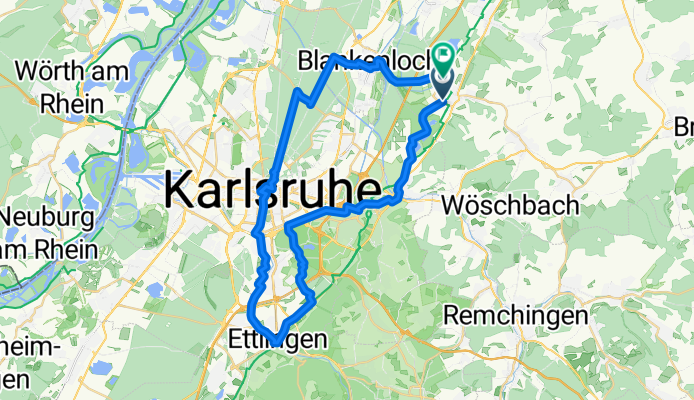
Weingarten Sonntagstour1
A cycling route starting in Weingarten, Baden-Wurttemberg, Germany.
Overview
About this route
Tour is perfect for a relaxed Sunday outing.
The tour avoids riding on the road.
For road bikes, it’s rather unsuitable due to the roadway conditions.
Tip: small break at Vogelbräu and a coffee in downtown Karlsruhe.
- -:--
 - Duration
 - 46.7 km
 - Distance
 - 108 m
 - Ascent
 - 104 m
 - Descent
 - ---
 - Avg. speed
 - 147 m
 - Max. altitude
 
Route quality
Waytypes & surfaces along the route
Waytypes
Track
17.3 km
(37 %)
Path
8.9 km
(19 %)
Surfaces
Paved
36 km
(77 %)
Unpaved
7 km
(15 %)
Asphalt
35.5 km
(76 %)
Gravel
6.1 km
(13 %)
Continue with Bikemap
Use, edit, or download this cycling route
You would like to ride Weingarten Sonntagstour1 or customize it for your own trip? Here is what you can do with this Bikemap route:
Free features
- Save this route as favorite or in collections
 - Copy & plan your own version of this route
 - Sync your route with Garmin or Wahoo
 
Premium features
Free trial for 3 days, or one-time payment. More about Bikemap Premium.
- Navigate this route on iOS & Android
 - Export a GPX / KML file of this route
 - Create your custom printout (try it for free)
 - Download this route for offline navigation
 
Discover more Premium features.
Get Bikemap PremiumFrom our community
Other popular routes starting in Weingarten
Tour 3- Distance
 - 17.7 km
 - Ascent
 - 43 m
 - Descent
 - 43 m
 - Location
 - Weingarten, Baden-Wurttemberg, Germany
 
Kraichgau-Nord-Schwarzwald-1- Distance
 - 55 km
 - Ascent
 - 359 m
 - Descent
 - 358 m
 - Location
 - Weingarten, Baden-Wurttemberg, Germany
 
lockere Pfinztal Runde- Distance
 - 48.7 km
 - Ascent
 - 387 m
 - Descent
 - 390 m
 - Location
 - Weingarten, Baden-Wurttemberg, Germany
 
Feierabendrunde um Weingarten- Distance
 - 26.2 km
 - Ascent
 - 342 m
 - Descent
 - 342 m
 - Location
 - Weingarten, Baden-Wurttemberg, Germany
 
See-Gond-Grom-Du- Distance
 - 40.9 km
 - Ascent
 - 273 m
 - Descent
 - 263 m
 - Location
 - Weingarten, Baden-Wurttemberg, Germany
 
Von Stutensee bis Straubenhardt- Distance
 - 32 km
 - Ascent
 - 672 m
 - Descent
 - 240 m
 - Location
 - Weingarten, Baden-Wurttemberg, Germany
 
Untergrombach über Augsteiner nach Unteröwisheim- Stettfeld und zurück- Distance
 - 26.3 km
 - Ascent
 - 182 m
 - Descent
 - 181 m
 - Location
 - Weingarten, Baden-Wurttemberg, Germany
 
Weingarten - Sternenfels - Maulbronn - Remchingen 85- Distance
 - 85 km
 - Ascent
 - 542 m
 - Descent
 - 545 m
 - Location
 - Weingarten, Baden-Wurttemberg, Germany
 
Open it in the app

