

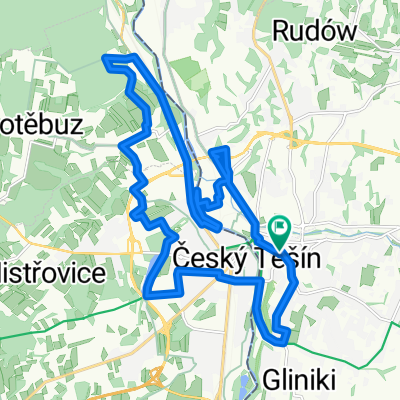
Tour de Mała Fatra
A cycling route starting in Cieszyn, Silesian Voivodeship, Poland.
Overview
About this route
- -:--
- Duration
- 260.8 km
- Distance
- 855 m
- Ascent
- 846 m
- Descent
- ---
- Avg. speed
- ---
- Max. altitude

Route quality
Waytypes & surfaces along the route
Waytypes
Quiet road
41.7 km
(16 %)
Road
33.9 km
(13 %)
Surfaces
Paved
156.5 km
(60 %)
Unpaved
2.6 km
(1 %)
Asphalt
151.3 km
(58 %)
Concrete
5.2 km
(2 %)
Route highlights
Points of interest along the route

Point of interest after 24.4 km
Jabłonków

Point of interest after 70.9 km
Żylina

Point of interest after 86.5 km
Stary hrad

Point of interest after 106.1 km
Mała Fatra

Point of interest after 122.8 km

Point of interest after 136.6 km
Dolny Kubin Velky Bysterec

Point of interest after 158.1 km
Zazriva ruiny kościoła

Point of interest after 164.1 km
Sedlo Rovna hora

Point of interest after 171.6 km
Vratna Tesnavy

Point of interest after 186.3 km
Sedlo Lutiska

Point of interest after 197.1 km
Stara Bystrica

Point of interest after 212.1 km
Kastiel Oszczadnica
Continue with Bikemap
Use, edit, or download this cycling route
You would like to ride Tour de Mała Fatra or customize it for your own trip? Here is what you can do with this Bikemap route:
Free features
- Save this route as favorite or in collections
- Copy & plan your own version of this route
- Split it into stages to create a multi-day tour
- Sync your route with Garmin or Wahoo
Premium features
Free trial for 3 days, or one-time payment. More about Bikemap Premium.
- Navigate this route on iOS & Android
- Export a GPX / KML file of this route
- Create your custom printout (try it for free)
- Download this route for offline navigation
Discover more Premium features.
Get Bikemap PremiumFrom our community
Other popular routes starting in Cieszyn
 Między Ostrawicą i Łucyną
- Distance
- 69.3 km
- Ascent
- 555 m
- Descent
- 555 m
- Location
- Cieszyn, Silesian Voivodeship, Poland
 Chata Ostry - Ropice - Hot. Ondrasz
- Distance
- 55.4 km
- Ascent
- 989 m
- Descent
- 989 m
- Location
- Cieszyn, Silesian Voivodeship, Poland
 W Dolomity (12 dni) 2002r
- Distance
- 2,273.5 km
- Ascent
- 34,645 m
- Descent
- 34,441 m
- Location
- Cieszyn, Silesian Voivodeship, Poland
 Cieszyn - Czeski Cieszyn "Bunkry"
- Distance
- 22.3 km
- Ascent
- 172 m
- Descent
- 173 m
- Location
- Cieszyn, Silesian Voivodeship, Poland
 Wokół Łysej Góry
- Distance
- 110.8 km
- Ascent
- 1,000 m
- Descent
- 1,000 m
- Location
- Cieszyn, Silesian Voivodeship, Poland
 Białogród i słupy graniczne
- Distance
- 80.7 km
- Ascent
- 273 m
- Descent
- 273 m
- Location
- Cieszyn, Silesian Voivodeship, Poland
 Hrčava
- Distance
- 103.3 km
- Ascent
- 692 m
- Descent
- 691 m
- Location
- Cieszyn, Silesian Voivodeship, Poland
 Tour de Mała Fatra
- Distance
- 260.8 km
- Ascent
- 855 m
- Descent
- 846 m
- Location
- Cieszyn, Silesian Voivodeship, Poland
Open it in the app