

Ruta 29 : Serrania de Cuenca - etapa 2
A cycling route starting in Uña, Castille-La Mancha, Spain.
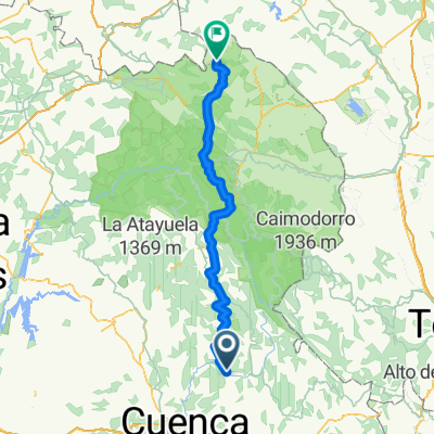
Overview
About this route
<ul>
<li>La Toba (1173m)</li>
<li>Huelamo (1218m).......................15</li>
<li>Tragacete (1279m)......................26</li>
<li>// CM-2106 //</li>
<li>>> Alto de la Vega (1504m).........36</li>
<li>// CM-2201 // (1542m).................54</li>
<li>Masegosa (1377m)..................60 km</li>
</ul>
Translated, show original (Spanish)- -:--
- Duration
- 60 km
- Distance
- 635 m
- Ascent
- 426 m
- Descent
- ---
- Avg. speed
- ---
- Max. altitude

Route quality
Waytypes & surfaces along the route
Waytypes
Road
0.6 km
(1 %)
Quiet road
0.6 km
(1 %)
Undefined
58.8 km
(98 %)
Surfaces
Paved
7.2 km
(12 %)
Paved (undefined)
5.4 km
(9 %)
Asphalt
1.8 km
(3 %)
Undefined
52.8 km
(88 %)
Continue with Bikemap
Use, edit, or download this cycling route
You would like to ride Ruta 29 : Serrania de Cuenca - etapa 2 or customize it for your own trip? Here is what you can do with this Bikemap route:
Free features
- Save this route as favorite or in collections
- Copy & plan your own version of this route
- Sync your route with Garmin or Wahoo
Premium features
Free trial for 3 days, or one-time payment. More about Bikemap Premium.
- Navigate this route on iOS & Android
- Export a GPX / KML file of this route
- Create your custom printout (try it for free)
- Download this route for offline navigation
Discover more Premium features.
Get Bikemap PremiumFrom our community
Other popular routes starting in Uña
 Laguna de Uña
- Distance
- 3.3 km
- Ascent
- 90 m
- Descent
- 87 m
- Location
- Uña, Castille-La Mancha, Spain
 Ruta 29 : Serrania de Cuenca - etapa 2
- Distance
- 60 km
- Ascent
- 635 m
- Descent
- 426 m
- Location
- Uña, Castille-La Mancha, Spain
 03 uña- villalba
- Distance
- 16.4 km
- Ascent
- 384 m
- Descent
- 557 m
- Location
- Uña, Castille-La Mancha, Spain
 Uña-Cuenca (7B)
- Distance
- 37 km
- Ascent
- 409 m
- Descent
- 616 m
- Location
- Uña, Castille-La Mancha, Spain
 Tramo Maraton Sendas de Cuenca 2015
- Distance
- 36.6 km
- Ascent
- 232 m
- Descent
- 397 m
- Location
- Uña, Castille-La Mancha, Spain
 Uña BTT Mochales
- Distance
- 146.4 km
- Ascent
- 1,974 m
- Descent
- 2,131 m
- Location
- Uña, Castille-La Mancha, Spain
 Tramo I Maraton Sendas de Cuenca. Buenache de la Sierra.
- Distance
- 25.9 km
- Ascent
- 641 m
- Descent
- 570 m
- Location
- Uña, Castille-La Mancha, Spain
 Sendero PR-CU 37 (CGSC)
- Distance
- 11 km
- Ascent
- 332 m
- Descent
- 332 m
- Location
- Uña, Castille-La Mancha, Spain
Open it in the app