

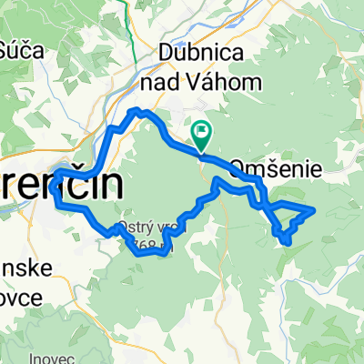
Trasa do Na Zongorke 7290/10, Trenčín
A cycling route starting in Trenčianske Teplice, Nitra Region, Slovakia.
Overview
About this route
- 9 min
- Duration
- 80.8 km
- Distance
- 524 m
- Ascent
- 939 m
- Descent
- 540.6 km/h
- Avg. speed
- ---
- Max. altitude

Route photos


Route quality
Waytypes & surfaces along the route
Waytypes
Track
46.1 km
(57 %)
Access road
10.5 km
(13 %)
Surfaces
Paved
39.6 km
(49 %)
Unpaved
25.9 km
(32 %)
Asphalt
38 km
(47 %)
Gravel
9.7 km
(12 %)
Continue with Bikemap
Use, edit, or download this cycling route
You would like to ride Trasa do Na Zongorke 7290/10, Trenčín or customize it for your own trip? Here is what you can do with this Bikemap route:
Free features
- Save this route as favorite or in collections
- Copy & plan your own version of this route
- Split it into stages to create a multi-day tour
- Sync your route with Garmin or Wahoo
Premium features
Free trial for 3 days, or one-time payment. More about Bikemap Premium.
- Navigate this route on iOS & Android
- Export a GPX / KML file of this route
- Create your custom printout (try it for free)
- Download this route for offline navigation
Discover more Premium features.
Get Bikemap PremiumFrom our community
Other popular routes starting in Trenčianske Teplice
 Tren. Teplice-TN-Lucky-Machnac-Baske-Tren. Teplice
- Distance
- 52.3 km
- Ascent
- 1,080 m
- Descent
- 1,080 m
- Location
- Trenčianske Teplice, Nitra Region, Slovakia
 Soblahovská chata-Trenčín
- Distance
- 12.6 km
- Ascent
- 131 m
- Descent
- 475 m
- Location
- Trenčianske Teplice, Nitra Region, Slovakia
 Trenčianske Teplice , Trenčín a späť.
- Distance
- 30.5 km
- Ascent
- 333 m
- Descent
- 371 m
- Location
- Trenčianske Teplice, Nitra Region, Slovakia
 Tr. Teplice-Dolna Poruba-Homolka a spat
- Distance
- 39.7 km
- Ascent
- 759 m
- Descent
- 759 m
- Location
- Trenčianske Teplice, Nitra Region, Slovakia
 Trasa do Na Zongorke 7290/10, Trenčín
- Distance
- 80.8 km
- Ascent
- 524 m
- Descent
- 939 m
- Location
- Trenčianske Teplice, Nitra Region, Slovakia
 17. novembra 37 do 17. novembra 290
- Distance
- 35.1 km
- Ascent
- 372 m
- Descent
- 441 m
- Location
- Trenčianske Teplice, Nitra Region, Slovakia
 Čierna Lehota - hrad Čierna Lehota - Baske - Omšenie
- Distance
- 13.1 km
- Ascent
- 704 m
- Descent
- 780 m
- Location
- Trenčianske Teplice, Nitra Region, Slovakia
 Homôlka-Zliechov-Mojtín-Košecké Podhradie-Iliavka-Dubnica.
- Distance
- 51.6 km
- Ascent
- 1,770 m
- Descent
- 2,164 m
- Location
- Trenčianske Teplice, Nitra Region, Slovakia
Open it in the app