Despoblado de Frontada
A cycling route starting in Cervera de Pisuerga, Castille and León, Spain.
Overview
About this route
This route will have as its destination the church of San Andrés in the abandoned village of Frontada, next to the Aguilar reservoir, the only reminder of what was once that population now submerged under the waters.
The round trip to Cervera de Pisuerga will be almost 48 kilometers of great visual beauty… great landscapes and no great difficulty except for the length of the ride.
Along the track parallel to the Pisuerga river we diverted at Barcenilla onto the path leading to Barrio de Santa María. There we take the road for about four kilometers to Foldada, ascend the climb at its exit and at the end, we turn onto the track that starts to our left and which four kilometers later leads us to the church of San Andrés.
The return is made the same way to total practically 48 kilometers.
- Highest point: 1,011 meters (km 19.5) at Alto de Foldada.
- Lowest point: 949 meters (km 14.5) next to the town of Barrio de Santa María.
- Total elevation gain: approximately 200 meters.
- -:--
- Duration
- 23 km
- Distance
- 132 m
- Ascent
- 169 m
- Descent
- ---
- Avg. speed
- ---
- Max. altitude
Route quality
Waytypes & surfaces along the route
Waytypes
Track
14 km
(61 %)
Road
5.7 km
(25 %)
Surfaces
Paved
4.6 km
(20 %)
Unpaved
15.4 km
(67 %)
Gravel
12 km
(52 %)
Asphalt
4.6 km
(20 %)
Continue with Bikemap
Use, edit, or download this cycling route
You would like to ride Despoblado de Frontada or customize it for your own trip? Here is what you can do with this Bikemap route:
Free features
- Save this route as favorite or in collections
- Copy & plan your own version of this route
- Sync your route with Garmin or Wahoo
Premium features
Free trial for 3 days, or one-time payment. More about Bikemap Premium.
- Navigate this route on iOS & Android
- Export a GPX / KML file of this route
- Create your custom printout (try it for free)
- Download this route for offline navigation
Discover more Premium features.
Get Bikemap PremiumFrom our community
Other popular routes starting in Cervera de Pisuerga
- Ruta pantanos. Montaña palentina. Cervera-Cervera
- Distance
- 97 km
- Ascent
- 727 m
- Descent
- 708 m
- Location
- Cervera de Pisuerga, Castille and León, Spain
- Etapa 1 . Vuelta a la Montaña Palentina . Cervera/Camasobres
- Distance
- 46.7 km
- Ascent
- 1,451 m
- Descent
- 1,261 m
- Location
- Cervera de Pisuerga, Castille and León, Spain
- Cervera de Pisuerga - Santuario de la Virgen del Brezo
- Distance
- 130.1 km
- Ascent
- 1,483 m
- Descent
- 1,243 m
- Location
- Cervera de Pisuerga, Castille and León, Spain
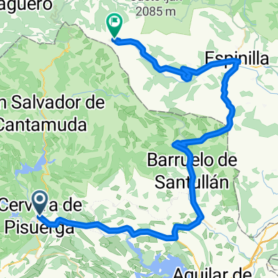
- Tag 4 von Cervera de Pisuera nach Mediana de Pomar
- Distance
- 112.7 km
- Ascent
- 634 m
- Descent
- 1,055 m
- Location
- Cervera de Pisuerga, Castille and León, Spain
- Lechetronica 2013
- Distance
- 163.7 km
- Ascent
- 0 m
- Descent
- 0 m
- Location
- Cervera de Pisuerga, Castille and León, Spain
- Cervera de pisuerga
- Distance
- 103.7 km
- Ascent
- 1,058 m
- Descent
- 1,062 m
- Location
- Cervera de Pisuerga, Castille and León, Spain
- Ruta de los Pantanos
- Distance
- 97.2 km
- Ascent
- 729 m
- Descent
- 729 m
- Location
- Cervera de Pisuerga, Castille and León, Spain
- Valsadornin - EL GOLOBAR - Aguilar de Campoo - Valsadornin
- Distance
- 108.6 km
- Ascent
- 1,828 m
- Descent
- 1,828 m
- Location
- Cervera de Pisuerga, Castille and León, Spain
Open it in the app