

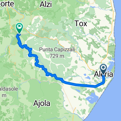
Korsika Rennradetappe Aleria nach Sagone
A cycling route starting in Aléria, Corsica, France.
Overview
About this route
From the east to the west coast of Corsica. It passes over the highest pass on the island that can be ridden. However, you should not take more than a backpack with essential items for the night. Both the departure and arrival points offer very good camping facilities that feature affordable and well-furnished chalets.
- -:--
- Duration
- 135.5 km
- Distance
- 2,102 m
- Ascent
- 2,093 m
- Descent
- ---
- Avg. speed
- ---
- Max. altitude

Route quality
Waytypes & surfaces along the route
Waytypes
Road
16.3 km
(12 %)
Quiet road
4.1 km
(3 %)
Surfaces
Paved
39.3 km
(29 %)
Asphalt
37.9 km
(28 %)
Paved (undefined)
1.4 km
(1 %)
Undefined
96.2 km
(71 %)
Continue with Bikemap
Use, edit, or download this cycling route
You would like to ride Korsika Rennradetappe Aleria nach Sagone or customize it for your own trip? Here is what you can do with this Bikemap route:
Free features
- Save this route as favorite or in collections
- Copy & plan your own version of this route
- Split it into stages to create a multi-day tour
- Sync your route with Garmin or Wahoo
Premium features
Free trial for 3 days, or one-time payment. More about Bikemap Premium.
- Navigate this route on iOS & Android
- Export a GPX / KML file of this route
- Create your custom printout (try it for free)
- Download this route for offline navigation
Discover more Premium features.
Get Bikemap PremiumFrom our community
Other popular routes starting in Aléria
 Aleria - Bocca De Sorba
- Distance
- 109.8 km
- Ascent
- 1,584 m
- Descent
- 1,583 m
- Location
- Aléria, Corsica, France
 Aléria-Bastia,kemp San Damiano
- Distance
- 92.9 km
- Ascent
- 172 m
- Descent
- 179 m
- Location
- Aléria, Corsica, France
 Korsika Rundtour, Etappe 06
- Distance
- 64.5 km
- Ascent
- 161 m
- Descent
- 154 m
- Location
- Aléria, Corsica, France
 Aleria - Chiatra - Moita - Tallone
- Distance
- 89.3 km
- Ascent
- 1,075 m
- Descent
- 1,076 m
- Location
- Aléria, Corsica, France
 Etang d'Urbino - Aleria - horske vesnicky - Corte
- Distance
- 73.9 km
- Ascent
- 1,108 m
- Descent
- 619 m
- Location
- Aléria, Corsica, France
 Aleria - Pancheraccia - Noceta
- Distance
- 94.6 km
- Ascent
- 1,387 m
- Descent
- 1,387 m
- Location
- Aléria, Corsica, France
 Aleria - Vezzani - Nozeta - D43/D143
- Distance
- 47.5 km
- Ascent
- 818 m
- Descent
- 575 m
- Location
- Aléria, Corsica, France
 Aleria - Antisanti - Aleria
- Distance
- 61.1 km
- Ascent
- 842 m
- Descent
- 844 m
- Location
- Aléria, Corsica, France
Open it in the app