

Podansko i Krolewskie Zrodlo
A cycling route starting in Goleniów, West Pomeranian Voivodeship, Poland.
Overview
About this route
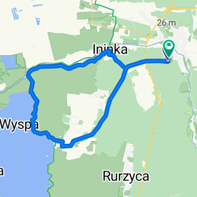
A short trip from Goleniów, where you can visit the recently renovated church in Podąńsko, the old cemetery in Podańsko, and then ride along a charming route with the Ina River on the side to visit the Royal Spring. The Goleniów-Podańsko segment first follows a bike path along the former railway route to Maszewo. Then you continue on a paved bike path to Podańsko, where you can see the church with a stone baptismal font and a World War I memorial. Concrete slabs take you up to the old cemetery. Next, a country road leads you to Zabrodzie. From there, you ride briefly on asphalt towards Goleniów and then turn into the forest at the barrier. Along the forest route, you will find signposts reading 'do źródła' (to the spring).
- -:--
- Duration
- 12.2 km
- Distance
- 68 m
- Ascent
- 66 m
- Descent
- ---
- Avg. speed
- ---
- Max. altitude

Route photos


Route quality
Waytypes & surfaces along the route
Waytypes
Path
5.5 km
(45 %)
Track
1.8 km
(15 %)
Surfaces
Paved
4.5 km
(37 %)
Unpaved
3.4 km
(28 %)
Asphalt
3.9 km
(32 %)
Ground
1.9 km
(16 %)
Continue with Bikemap
Use, edit, or download this cycling route
You would like to ride Podansko i Krolewskie Zrodlo or customize it for your own trip? Here is what you can do with this Bikemap route:
Free features
- Save this route as favorite or in collections
- Copy & plan your own version of this route
- Sync your route with Garmin or Wahoo
Premium features
Free trial for 3 days, or one-time payment. More about Bikemap Premium.
- Navigate this route on iOS & Android
- Export a GPX / KML file of this route
- Create your custom printout (try it for free)
- Download this route for offline navigation
Discover more Premium features.
Get Bikemap PremiumFrom our community
Other popular routes starting in Goleniów
 Quick bike tour through Szczecin
- Distance
- 33.7 km
- Ascent
- 51 m
- Descent
- 31 m
- Location
- Goleniów, West Pomeranian Voivodeship, Poland
 Teil 19: Von Gmina Goleniów bis Swinemünde
- Distance
- 84.1 km
- Ascent
- 283 m
- Descent
- 283 m
- Location
- Goleniów, West Pomeranian Voivodeship, Poland
 Szczecińska do Szczecińska
- Distance
- 30 km
- Ascent
- 30 m
- Descent
- 61 m
- Location
- Goleniów, West Pomeranian Voivodeship, Poland
 Szkolna 40B, Goleniów do Szarych Szeregów 9C, Goleniów
- Distance
- 52.3 km
- Ascent
- 967 m
- Descent
- 966 m
- Location
- Goleniów, West Pomeranian Voivodeship, Poland
 Goleniów-most na Inie-Komarowo-Goleniów
- Distance
- 24.5 km
- Ascent
- 60 m
- Descent
- 59 m
- Location
- Goleniów, West Pomeranian Voivodeship, Poland
 Zdzary do pomnika poległych w I ws z psiakiem
- Distance
- 9.7 km
- Ascent
- 61 m
- Descent
- 61 m
- Location
- Goleniów, West Pomeranian Voivodeship, Poland
 Viereck
- Distance
- 52.6 km
- Ascent
- 108 m
- Descent
- 116 m
- Location
- Goleniów, West Pomeranian Voivodeship, Poland
 wał 26
- Distance
- 55 km
- Ascent
- 36 m
- Descent
- 31 m
- Location
- Goleniów, West Pomeranian Voivodeship, Poland
Open it in the app