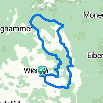
Naturparkwanderweg(10000 Schritte)
A cycling route starting in Langschlag, Lower Austria, Austria.
Overview
About this route
- -:--
- Duration
- 7.1 km
- Distance
- 178 m
- Ascent
- 178 m
- Descent
- ---
- Avg. speed
- ---
- Avg. speed
Route quality
Waytypes & surfaces along the route
Waytypes
Track
5 km
(71 %)
Quiet road
1.5 km
(22 %)
Surfaces
Paved
0 km
(<1 %)
Unpaved
4 km
(56 %)
Gravel
2.3 km
(32 %)
Unpaved (undefined)
1.3 km
(17 %)
Route highlights
Points of interest along the route
Point of interest after 3 km
Anna Freitag Denkmal
Point of interest after 3.7 km
Bettelweibstein
Continue with Bikemap
Use, edit, or download this cycling route
You would like to ride Naturparkwanderweg(10000 Schritte) or customize it for your own trip? Here is what you can do with this Bikemap route:
Free features
- Save this route as favorite or in collections
- Copy & plan your own version of this route
- Sync your route with Garmin or Wahoo
Premium features
Free trial for 3 days, or one-time payment. More about Bikemap Premium.
- Navigate this route on iOS & Android
- Export a GPX / KML file of this route
- Create your custom printout (try it for free)
- Download this route for offline navigation
Discover more Premium features.
Get Bikemap PremiumFrom our community
Other popular routes starting in Langschlag
- Nebelstein Radtour
- Distance
- 51.5 km
- Ascent
- 1,025 m
- Descent
- 1,019 m
- Location
- Langschlag, Lower Austria, Austria
- Schöneben - Grein
- Distance
- 67.5 km
- Ascent
- 675 m
- Descent
- 1,315 m
- Location
- Langschlag, Lower Austria, Austria
- Am Berg 170, Langschlag nach Am Berg 170, Langschlag
- Distance
- 6.8 km
- Ascent
- 126 m
- Descent
- 174 m
- Location
- Langschlag, Lower Austria, Austria
- Antenfeinhöfen Vorgang
- Distance
- 7.4 km
- Ascent
- 197 m
- Descent
- 196 m
- Location
- Langschlag, Lower Austria, Austria
- Nordwaldtour
- Distance
- 38.2 km
- Ascent
- 197 m
- Descent
- 625 m
- Location
- Langschlag, Lower Austria, Austria
- Tannermoor
- Distance
- 38.7 km
- Ascent
- 757 m
- Descent
- 759 m
- Location
- Langschlag, Lower Austria, Austria
- Panorama
- Distance
- 40.7 km
- Ascent
- 826 m
- Descent
- 830 m
- Location
- Langschlag, Lower Austria, Austria
- Gravel Austria, Etappe Niederösterreich
- Distance
- 522.8 km
- Ascent
- 7,970 m
- Descent
- 8,788 m
- Location
- Langschlag, Lower Austria, Austria
Open it in the app