

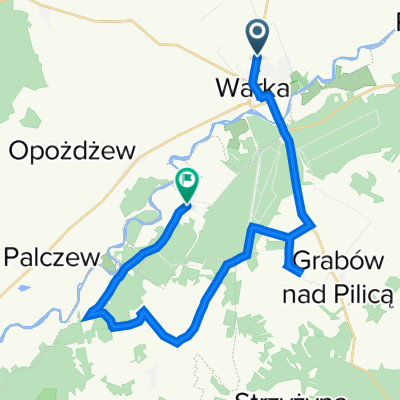
34. Warka Tour 2011: 850km/24h CLONED FROM ROUTE 574107
A cycling route starting in Warka, Masovian Voivodeship, Poland.
Overview
About this route
start o godz. 8:00
19 rund x 44.8km = 851km
koniec o godz. 8:00
- -:--
- Duration
- 44.8 km
- Distance
- 69 m
- Ascent
- 69 m
- Descent
- ---
- Avg. speed
- ---
- Max. altitude
Route quality
Waytypes & surfaces along the route
Waytypes
Quiet road
13.4 km
(30 %)
Road
7.2 km
(16 %)
Surfaces
Paved
31.4 km
(70 %)
Unpaved
1.3 km
(3 %)
Asphalt
31.4 km
(70 %)
Unpaved (undefined)
1.3 km
(3 %)
Undefined
12.1 km
(27 %)
Continue with Bikemap
Use, edit, or download this cycling route
You would like to ride 34. Warka Tour 2011: 850km/24h CLONED FROM ROUTE 574107 or customize it for your own trip? Here is what you can do with this Bikemap route:
Free features
- Save this route as favorite or in collections
- Copy & plan your own version of this route
- Sync your route with Garmin or Wahoo
Premium features
Free trial for 3 days, or one-time payment. More about Bikemap Premium.
- Navigate this route on iOS & Android
- Export a GPX / KML file of this route
- Create your custom printout (try it for free)
- Download this route for offline navigation
Discover more Premium features.
Get Bikemap PremiumFrom our community
Other popular routes starting in Warka
 Road fot Gold
- Distance
- 128.9 km
- Ascent
- 114 m
- Descent
- 114 m
- Location
- Warka, Masovian Voivodeship, Poland
 20100703 Warka 2010: 814km/24h
- Distance
- 56.3 km
- Ascent
- 101 m
- Descent
- 101 m
- Location
- Warka, Masovian Voivodeship, Poland
 34. Warka Tour 2011: 850km/24h CLONED FROM ROUTE 574107
- Distance
- 44.8 km
- Ascent
- 69 m
- Descent
- 69 m
- Location
- Warka, Masovian Voivodeship, Poland
 Warka - Wilanów
- Distance
- 55.9 km
- Ascent
- 60 m
- Descent
- 98 m
- Location
- Warka, Masovian Voivodeship, Poland
 z Warki
- Distance
- 10.5 km
- Ascent
- 0 m
- Descent
- 0 m
- Location
- Warka, Masovian Voivodeship, Poland
 Warka - Mokotow
- Distance
- 58.4 km
- Ascent
- 95 m
- Descent
- 108 m
- Location
- Warka, Masovian Voivodeship, Poland
 Warka - ROD Borowiec przez Białobrzegi i Mogielnicę
- Distance
- 102.6 km
- Ascent
- 225 m
- Descent
- 164 m
- Location
- Warka, Masovian Voivodeship, Poland
 Filtrowa 2–2A, Warka do Kępa Niemojewska 2, Budy Grzegorzewskie
- Distance
- 26.7 km
- Ascent
- 170 m
- Descent
- 204 m
- Location
- Warka, Masovian Voivodeship, Poland
Open it in the app