BALPANY 2011
A cycling route starting in Stari Grad, Central Serbia, Serbia.
Overview
About this route
8 państw w trakcie wyprawy + 4 podczas przejazdu tranzytowego
- -:--
- Duration
- 2,127.5 km
- Distance
- 7,637 m
- Ascent
- 6,932 m
- Descent
- ---
- Avg. speed
- ---
- Max. altitude
Route highlights
Points of interest along the route

Photo after 301 km
Słynny most nad Tarą

Photo after 341.6 km
Durmitor

Photo after 365.2 km
Droga Tuneli

Photo after 371.7 km
Jezioro Pivskie

Photo after 557.4 km
Mauzoleum Petra Njegosha, władcy Czarnogóry

Photo after 566.4 km
Przełęcz Krstac, "jedna z najpiękniejszych dróg Europy" https://picasaweb.google.com/wilku150/BalkAlpin2009#5401709718126438194

Photo after 589.4 km
Zatoka Kotorska - jedyny europejski fiord poza Norwegią
Point of interest after 603.1 km
Bezpłatny prom dla rowerzystów

Photo after 753.4 km
Mostar

Point of interest after 967.1 km
Park Narodowy Krka

Photo after 1,103.3 km
Szutrowa przełęcz Mali Alan http://www.cro.pl/forum/viewtopic.php?t=17616
Point of interest after 1,401 km
Hum - najmniejsze miasto na świecie, liczy zaledwie 14 mieszkańców

Point of interest after 1,436.8 km
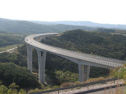
Niesamowity wiadukt drogowy w Crni Kale, najwyższy i najdłuższy w Słowenii
Point of interest after 1,436.9 km
Point of interest after 1,982.7 km
Przełęcz Bernina
Point of interest after 1,982.7 km
Przełęcz Forcla de Livigno
Point of interest after 2,029.6 km
Przełęcz Passo dello Stelvio 2757m n.p.m. Profil wysokościowy: http://www.climbbybike.com/profile.asp?Climbprofile=Passo-dello-Stelvio&MountainID=38
Point of interest after 2,113.7 km
Przełęcz Timmelsjoch
Continue with Bikemap
Use, edit, or download this cycling route
You would like to ride BALPANY 2011 or customize it for your own trip? Here is what you can do with this Bikemap route:
Free features
- Save this route as favorite or in collections
- Copy & plan your own version of this route
- Split it into stages to create a multi-day tour
- Sync your route with Garmin or Wahoo
Premium features
Free trial for 3 days, or one-time payment. More about Bikemap Premium.
- Navigate this route on iOS & Android
- Export a GPX / KML file of this route
- Create your custom printout (try it for free)
- Download this route for offline navigation
Discover more Premium features.
Get Bikemap PremiumFrom our community
Other popular routes starting in Stari Grad
 BA 000 - Бeoгpaд - Αγίου Όρους
- Distance
- 1,023.8 km
- Ascent
- 3,344 m
- Descent
- 3,430 m
- Location
- Stari Grad, Central Serbia, Serbia
 Route to Вртић Меда - Жута кућа
- Distance
- 15.7 km
- Ascent
- 248 m
- Descent
- 156 m
- Location
- Stari Grad, Central Serbia, Serbia
 Belgrade, Serbia to Drobeta-Turnu Severin, Romania
- Distance
- 295.5 km
- Ascent
- 769 m
- Descent
- 757 m
- Location
- Stari Grad, Central Serbia, Serbia
 From Belgrade to Surčin
- Distance
- 34.6 km
- Ascent
- 70 m
- Descent
- 80 m
- Location
- Stari Grad, Central Serbia, Serbia
 BALPANY 2011
- Distance
- 2,127.5 km
- Ascent
- 7,637 m
- Descent
- 6,932 m
- Location
- Stari Grad, Central Serbia, Serbia
 18 Looking for bike repair shops
- Distance
- 14 km
- Ascent
- 205 m
- Descent
- 149 m
- Location
- Stari Grad, Central Serbia, Serbia
 Beograd - Istanbul: tour 2013
- Distance
- 967.6 km
- Ascent
- 1,608 m
- Descent
- 1,646 m
- Location
- Stari Grad, Central Serbia, Serbia
 Beograd to Novi Sad
- Distance
- 90.1 km
- Ascent
- 224 m
- Descent
- 258 m
- Location
- Stari Grad, Central Serbia, Serbia
Open it in the app


