

Fuente Deshondonada
A cycling route starting in Cervera de Pisuerga, Castille and León, Spain.
Overview
About this route
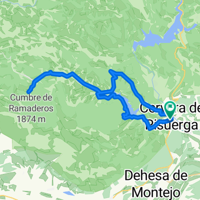
Route through the valley of the Rivera River or Narrow Valley of just over 31 kilometers in length.
Starting from Cervera de Pisuerga, we will travel by road to Ruesga, where at the exit we will take the path that leads us along the edge of the Ruesga Reservoir until we reach Ventanilla. In this town, we will cross the Rivera River on its bridge to find the road again (P-210) until we reach a junction two kilometers later to head towards Rebanal de las Llantas.
After traveling three kilometers on this new road, we will leave it to cross the Rebanal stream via the existing footbridge, which places us on the track that will take us to the source of the Rivera River, also known as Fuente Deshondonada.
We will return to Ventanilla by the same route taken. After passing Ventanilla, we will continue along the road for just over a kilometer until the road makes a wide curve. To the left, there appears a track that runs through a small valley and climbs to the road that connects the Parador de Fuentes Carrionas and Resoba.
Turning left, we will ascend to the Parador and finally descend to Cervera.
<span style="font-family: Arial, Helvetica, sans-serif; font-size: 11px;"> </span>
<span style="border-collapse: collapse; color: #333333; font-family: 'lucida grande', tahoma, verdana, arial, sans-serif; font-size: 11px; line-height: 15px; padding: 0px; margin: 0px;">TECHNICAL SHEET:<br style="padding: 0px; margin: 0px;" /></span>
Distance: 31.2 km.
Difficulty: medium.
Elevation gain: 330 m.
Highest point: 1,172 meters (km 25.7) at the site known as La Pedragosa.
Lowest point: 1,003 meters (km 0.0) at the starting point in Cervera de Pisuerga.
- -:--
- Duration
- 31.2 km
- Distance
- 320 m
- Ascent
- 320 m
- Descent
- ---
- Avg. speed
- ---
- Max. altitude
Route quality
Waytypes & surfaces along the route
Waytypes
Road
21.2 km
(68 %)
Track
9 km
(29 %)
Quiet road
0.9 km
(3 %)
Surfaces
Paved
20.9 km
(67 %)
Unpaved
7.5 km
(24 %)
Asphalt
20.9 km
(67 %)
Ground
5.6 km
(18 %)
Continue with Bikemap
Use, edit, or download this cycling route
You would like to ride Fuente Deshondonada or customize it for your own trip? Here is what you can do with this Bikemap route:
Free features
- Save this route as favorite or in collections
- Copy & plan your own version of this route
- Sync your route with Garmin or Wahoo
Premium features
Free trial for 3 days, or one-time payment. More about Bikemap Premium.
- Navigate this route on iOS & Android
- Export a GPX / KML file of this route
- Create your custom printout (try it for free)
- Download this route for offline navigation
Discover more Premium features.
Get Bikemap PremiumFrom our community
Other popular routes starting in Cervera de Pisuerga
 de los Tres Valles
- Distance
- 27.9 km
- Ascent
- 225 m
- Descent
- 218 m
- Location
- Cervera de Pisuerga, Castille and León, Spain
 Cervera de pisuerga
- Distance
- 103.7 km
- Ascent
- 1,058 m
- Descent
- 1,062 m
- Location
- Cervera de Pisuerga, Castille and León, Spain
 Lechetronica 2013
- Distance
- 163.7 km
- Ascent
- 0 m
- Descent
- 0 m
- Location
- Cervera de Pisuerga, Castille and León, Spain
 Despoblado de Frontada
- Distance
- 23 km
- Ascent
- 132 m
- Descent
- 169 m
- Location
- Cervera de Pisuerga, Castille and León, Spain
 Fuente Deshondonada
- Distance
- 31.2 km
- Ascent
- 320 m
- Descent
- 320 m
- Location
- Cervera de Pisuerga, Castille and León, Spain
 Valsadornin - EL GOLOBAR - Aguilar de Campoo - Valsadornin
- Distance
- 108.6 km
- Ascent
- 1,828 m
- Descent
- 1,828 m
- Location
- Cervera de Pisuerga, Castille and León, Spain
 Tag 4 von Cervera de Pisuera nach Mediana de Pomar
- Distance
- 112.7 km
- Ascent
- 634 m
- Descent
- 1,055 m
- Location
- Cervera de Pisuerga, Castille and León, Spain
 Ruta pantanos. Montaña palentina. Cervera-Cervera
- Distance
- 97 km
- Ascent
- 727 m
- Descent
- 708 m
- Location
- Cervera de Pisuerga, Castille and León, Spain
Open it in the app