
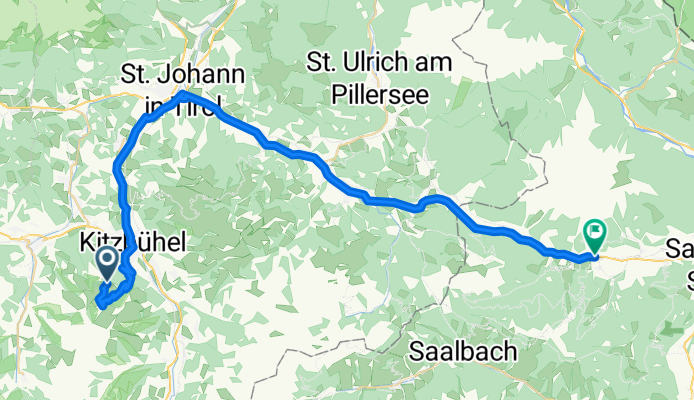
Hannenkam-Kitzbühel-Leogang
A cycling route starting in Kitzbühel, Tyrol, Austria.
Overview
About this route
Čím více zde napíšete informací, tím více bude užitečnější pro ostatním uživatele.<br /><br />* Průběh trasy.<br />* Co je zvláštní na této trase?<br />* Proč doporučit tuto trasu?<br />* Co se Vám zde nejvíce líbilo?<br />* Atd.
- -:--
- Duration
- 46.7 km
- Distance
- 333 m
- Ascent
- 1,163 m
- Descent
- ---
- Avg. speed
- ---
- Max. altitude
Route quality
Waytypes & surfaces along the route
Waytypes
Busy road
26.8 km
(57 %)
Access road
9 km
(19 %)
Surfaces
Paved
30.5 km
(65 %)
Unpaved
0.1 km
(<1 %)
Asphalt
25.9 km
(55 %)
Paved (undefined)
4.6 km
(10 %)
Continue with Bikemap
Use, edit, or download this cycling route
You would like to ride Hannenkam-Kitzbühel-Leogang or customize it for your own trip? Here is what you can do with this Bikemap route:
Free features
- Save this route as favorite or in collections
- Copy & plan your own version of this route
- Sync your route with Garmin or Wahoo
Premium features
Free trial for 3 days, or one-time payment. More about Bikemap Premium.
- Navigate this route on iOS & Android
- Export a GPX / KML file of this route
- Create your custom printout (try it for free)
- Download this route for offline navigation
Discover more Premium features.
Get Bikemap PremiumFrom our community
Other popular routes starting in Kitzbühel
 Hannenkam-Kitzbühel-Leogang
- Distance
- 46.7 km
- Ascent
- 333 m
- Descent
- 1,163 m
- Location
- Kitzbühel, Tyrol, Austria
 Aurach - Reith - Astberg - Ellmau - Oberndorf
- Distance
- 43.7 km
- Ascent
- 692 m
- Descent
- 692 m
- Location
- Kitzbühel, Tyrol, Austria
 Im Gries 11, Kitzbühel nach Im Gries 15, Kitzbühel
- Distance
- 63.6 km
- Ascent
- 673 m
- Descent
- 671 m
- Location
- Kitzbühel, Tyrol, Austria
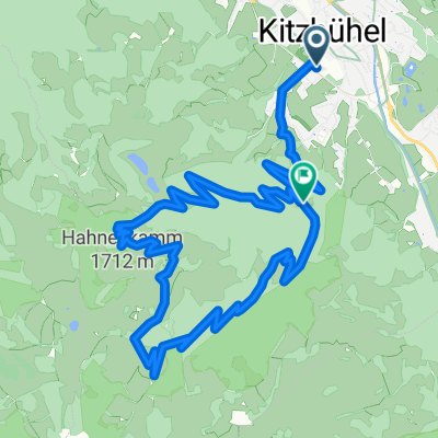 Hahnekamm
- Distance
- 13.6 km
- Ascent
- 892 m
- Descent
- 619 m
- Location
- Kitzbühel, Tyrol, Austria
 Kitzbuheler Horn
- Distance
- 48.1 km
- Ascent
- 1,504 m
- Descent
- 1,503 m
- Location
- Kitzbühel, Tyrol, Austria
 Im Gries 11, Kitzbühel nach Im Gries 20, Kitzbühel
- Distance
- 68.1 km
- Ascent
- 964 m
- Descent
- 963 m
- Location
- Kitzbühel, Tyrol, Austria
 Fleckalm Trail
- Distance
- 7 km
- Ascent
- 6 m
- Descent
- 981 m
- Location
- Kitzbühel, Tyrol, Austria
 Kitzbuhel2_Hahnenkamm_Ashau_Kitz
- Distance
- 45.6 km
- Ascent
- 434 m
- Descent
- 1,320 m
- Location
- Kitzbühel, Tyrol, Austria
Open it in the app