

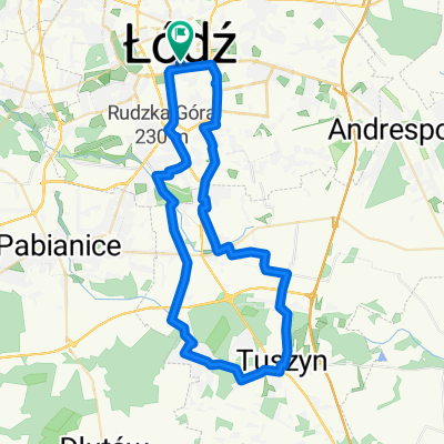
Na południe
A cycling route starting in Lodz, Łódź Voivodeship, Poland.
Overview
About this route
- -:--
- Duration
- 48 km
- Distance
- 76 m
- Ascent
- 72 m
- Descent
- ---
- Avg. speed
- ---
- Max. altitude

Route quality
Waytypes & surfaces along the route
Waytypes
Cycleway
16.2 km
(34 %)
Road
14.5 km
(30 %)
Surfaces
Paved
36.7 km
(76 %)
Unpaved
0.2 km
(<1 %)
Asphalt
30.8 km
(64 %)
Paving stones
5.8 km
(12 %)
Continue with Bikemap
Use, edit, or download this cycling route
You would like to ride Na południe or customize it for your own trip? Here is what you can do with this Bikemap route:
Free features
- Save this route as favorite or in collections
- Copy & plan your own version of this route
- Sync your route with Garmin or Wahoo
Premium features
Free trial for 3 days, or one-time payment. More about Bikemap Premium.
- Navigate this route on iOS & Android
- Export a GPX / KML file of this route
- Create your custom printout (try it for free)
- Download this route for offline navigation
Discover more Premium features.
Get Bikemap PremiumFrom our community
Other popular routes starting in Lodz
 Szosa: Rzgowska
- Distance
- 72.4 km
- Ascent
- 196 m
- Descent
- 201 m
- Location
- Lodz, Łódź Voivodeship, Poland
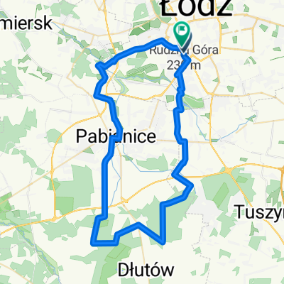
 2019-06-29: Łódź - Gospodarz - Rydzynki - Tuszyn - Modlica - Rzgów - Łódź
- Distance
- 54.9 km
- Ascent
- 112 m
- Descent
- 112 m
- Location
- Lodz, Łódź Voivodeship, Poland
 Na południe
- Distance
- 48 km
- Ascent
- 76 m
- Descent
- 72 m
- Location
- Lodz, Łódź Voivodeship, Poland
 Route to Zgierz
- Distance
- 12.5 km
- Ascent
- 60 m
- Descent
- 87 m
- Location
- Lodz, Łódź Voivodeship, Poland
 Kaszek_v3
- Distance
- 45.5 km
- Ascent
- 179 m
- Descent
- 177 m
- Location
- Lodz, Łódź Voivodeship, Poland
 Pętla 20km - Łódź
- Distance
- 21.5 km
- Ascent
- 72 m
- Descent
- 76 m
- Location
- Lodz, Łódź Voivodeship, Poland
 Las Dąbrowa
- Distance
- 56.8 km
- Ascent
- 141 m
- Descent
- 151 m
- Location
- Lodz, Łódź Voivodeship, Poland
 trzydziecha
- Distance
- 30.1 km
- Ascent
- 215 m
- Descent
- 218 m
- Location
- Lodz, Łódź Voivodeship, Poland
Open it in the app