

MTB-Tour El Golfo
A cycling route starting in Yaiza, Canary Islands, Spain.
Overview
About this route
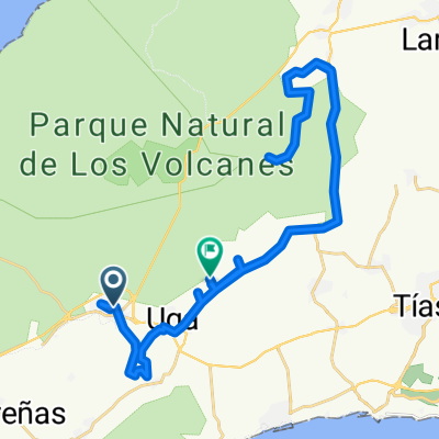
A pleasure ride, with all the beauties that the west coast around EL Golfo offers. From the turnoff (km 3.5) through the lava landscape toward Salinas de Janubio is military restricted area, although I have never encountered military personnel there. Passing the salt flats and Los Hervideros (a unique spectacle of sea and surf), onward to Charco de los Ciclos with its green water, on LZ 704 towards Yaiza, turnoff into the terrain – for those who wish to visit the lonely Playa del Paso, note: from km 18.5 runs the border of Timanfaya National Park, which is generally closed to MTB, rangers monitor the area, no problems on foot – and back on LZ 703 to EL Golfo. If you arrive at El Golfo late in the afternoon, you will witness the most beautiful sunsets on the island.
- -:--
- Duration
- 39.7 km
- Distance
- 424 m
- Ascent
- 424 m
- Descent
- ---
- Avg. speed
- ---
- Max. altitude
Route highlights
Points of interest along the route

Photo after 7.9 km

Photo after 10.7 km

Photo after 11.3 km

Photo after 14 km

Photo after 23.7 km

Photo after 25.7 km

Photo after 25.9 km

Photo after 26 km
Continue with Bikemap
Use, edit, or download this cycling route
You would like to ride MTB-Tour El Golfo or customize it for your own trip? Here is what you can do with this Bikemap route:
Free features
- Save this route as favorite or in collections
- Copy & plan your own version of this route
- Sync your route with Garmin or Wahoo
Premium features
Free trial for 3 days, or one-time payment. More about Bikemap Premium.
- Navigate this route on iOS & Android
- Export a GPX / KML file of this route
- Create your custom printout (try it for free)
- Download this route for offline navigation
Discover more Premium features.
Get Bikemap PremiumFrom our community
Other popular routes starting in Yaiza
 Inside Lanzartote 10.06.2018
- Distance
- 19.5 km
- Ascent
- 221 m
- Descent
- 217 m
- Location
- Yaiza, Canary Islands, Spain
 Calle la Orilla to Vía Sin Nombre
- Distance
- 48.4 km
- Ascent
- 848 m
- Descent
- 772 m
- Location
- Yaiza, Canary Islands, Spain
 Yaiza - Haría
- Distance
- 88 km
- Ascent
- 2,034 m
- Descent
- 1,873 m
- Location
- Yaiza, Canary Islands, Spain
 19-01-11 Yaiza - Playa Blanca (LZ) - Corralejo - Almacigo (FV)
- Distance
- 66.8 km
- Ascent
- 389 m
- Descent
- 363 m
- Location
- Yaiza, Canary Islands, Spain
 De Calle de los Molinos, 4, Yaiza a Calle de los Molinos, 4, Yaiza
- Distance
- 16.8 km
- Ascent
- 71 m
- Descent
- 90 m
- Location
- Yaiza, Canary Islands, Spain
 Yaiza in die Feuerberge
- Distance
- 35.8 km
- Ascent
- 473 m
- Descent
- 477 m
- Location
- Yaiza, Canary Islands, Spain
 Calle del Pico Redondo, Yaiza a Calle Taburiente, 10, Tías
- Distance
- 19.9 km
- Ascent
- 573 m
- Descent
- 753 m
- Location
- Yaiza, Canary Islands, Spain
 lanza-Test
- Distance
- 40 km
- Ascent
- 424 m
- Descent
- 424 m
- Location
- Yaiza, Canary Islands, Spain
Open it in the app