
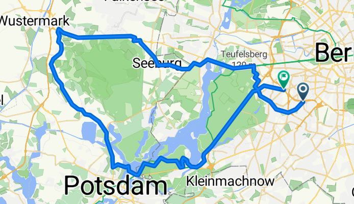
S/U Bundesplatz - A'tunnel - Wannseehügel - Elstal - Seeburg - Heerstr - S Grunewald - S Hohenzollerndamm
A cycling route starting in Friedenau, State of Berlin, Germany.
Overview
About this route
- -:--
- Duration
- 72.8 km
- Distance
- 190 m
- Ascent
- 187 m
- Descent
- ---
- Avg. speed
- ---
- Max. altitude

Route highlights
Points of interest along the route
Point of interest after 42.4 km
Continue with Bikemap
Use, edit, or download this cycling route
You would like to ride S/U Bundesplatz - A'tunnel - Wannseehügel - Elstal - Seeburg - Heerstr - S Grunewald - S Hohenzollerndamm or customize it for your own trip? Here is what you can do with this Bikemap route:
Free features
- Save this route as favorite or in collections
- Copy & plan your own version of this route
- Sync your route with Garmin or Wahoo
Premium features
Free trial for 3 days, or one-time payment. More about Bikemap Premium.
- Navigate this route on iOS & Android
- Export a GPX / KML file of this route
- Create your custom printout (try it for free)
- Download this route for offline navigation
Discover more Premium features.
Get Bikemap PremiumFrom our community
Other popular routes starting in Friedenau
 Hügelige Feierabendrunde
- Distance
- 68.3 km
- Ascent
- 505 m
- Descent
- 497 m
- Location
- Friedenau, State of Berlin, Germany
 Feierabendrunde über Gröben & Ludwigsfelde
- Distance
- 68.7 km
- Ascent
- 95 m
- Descent
- 91 m
- Location
- Friedenau, State of Berlin, Germany
 Friedenau-Grunewaldturm-Friedenau
- Distance
- 28.7 km
- Ascent
- 177 m
- Descent
- 174 m
- Location
- Friedenau, State of Berlin, Germany
 Nachtfahrt Rennrad/Südwest
- Distance
- 26.9 km
- Ascent
- 70 m
- Descent
- 67 m
- Location
- Friedenau, State of Berlin, Germany
 Kleine Feierabendrunde im Grunewald
- Distance
- 37.1 km
- Ascent
- 151 m
- Descent
- 153 m
- Location
- Friedenau, State of Berlin, Germany
 S/U Bundesplatz - S Zehlendorf - Tremsdorf - Dobbrikow - Trebbin - Riesengroßbeuthen - Nudow - Drewitz - S Wannsee
- Distance
- 94.1 km
- Ascent
- 124 m
- Descent
- 124 m
- Location
- Friedenau, State of Berlin, Germany
 Friedenau-Trebbin
- Distance
- 85.5 km
- Ascent
- 88 m
- Descent
- 86 m
- Location
- Friedenau, State of Berlin, Germany
 He-GliB-Grieb-He
- Distance
- 49.8 km
- Ascent
- 287 m
- Descent
- 289 m
- Location
- Friedenau, State of Berlin, Germany
Open it in the app