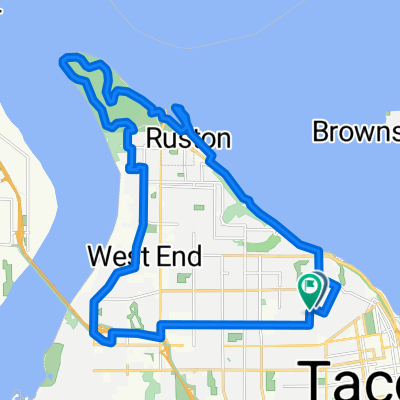
Narrows Bridge via Scott Pierson Trail
A cycling route starting in Tacoma, Washington, United States of America.
Overview
About this route
- -:--
- Duration
- 24.4 km
- Distance
- 268 m
- Ascent
- 271 m
- Descent
- ---
- Avg. speed
- ---
- Avg. speed
Route quality
Waytypes & surfaces along the route
Waytypes
Quiet road
8.6 km
(35 %)
Cycleway
7.5 km
(31 %)
Surfaces
Paved
5.6 km
(23 %)
Paved (undefined)
3 km
(12 %)
Asphalt
2.7 km
(11 %)
Undefined
18.8 km
(77 %)
Continue with Bikemap
Use, edit, or download this cycling route
You would like to ride Narrows Bridge via Scott Pierson Trail or customize it for your own trip? Here is what you can do with this Bikemap route:
Free features
- Save this route as favorite or in collections
- Copy & plan your own version of this route
- Sync your route with Garmin or Wahoo
Premium features
Free trial for 3 days, or one-time payment. More about Bikemap Premium.
- Navigate this route on iOS & Android
- Export a GPX / KML file of this route
- Create your custom printout (try it for free)
- Download this route for offline navigation
Discover more Premium features.
Get Bikemap PremiumFrom our community
Other popular routes starting in Tacoma
- Tacoma Cycling
- Distance
- 18.1 km
- Ascent
- 276 m
- Descent
- 265 m
- Location
- Tacoma, Washington, United States of America
- ups loop
- Distance
- 3.4 km
- Ascent
- 31 m
- Descent
- 32 m
- Location
- Tacoma, Washington, United States of America
- work to home
- Distance
- 8.7 km
- Ascent
- 85 m
- Descent
- 84 m
- Location
- Tacoma, Washington, United States of America
- Moderate route in Ruston
- Distance
- 4.6 km
- Ascent
- 0 m
- Descent
- 3 m
- Location
- Tacoma, Washington, United States of America
- Steady ride in Tacoma
- Distance
- 13.9 km
- Ascent
- 329 m
- Descent
- 331 m
- Location
- Tacoma, Washington, United States of America
- 2201 Ruston Way, Tacoma to 5426–5434 Water Slote St, Tacoma
- Distance
- 4.8 km
- Ascent
- 0 m
- Descent
- 3 m
- Location
- Tacoma, Washington, United States of America
- Ruston bike route
- Distance
- 17.7 km
- Ascent
- 155 m
- Descent
- 156 m
- Location
- Tacoma, Washington, United States of America
- Charlotte's Blueberry Farm Loop
- Distance
- 11.7 km
- Ascent
- 60 m
- Descent
- 59 m
- Location
- Tacoma, Washington, United States of America