

Rund um Berlin / Tour Michelin
A cycling route starting in Wannsee, State of Berlin, Germany.
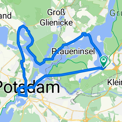
Overview
About this route
Potsdam, Rudolf-Moos-Str: BK Potsdam, Horstweg: McD Dallgow, Döberitzer Weg 3, McD B-Staaken, Heerstr: McD, Hennigsdorf, Veltener Straße 16, McD Bernau, Johann-Friedrich-A.-Borsig-Straße, McD Blumberg, Am Rehhahn: McD Vogelsdorf, Frankfurter Chaussee 66: BK Erkner, Berliner Straße 12, McD Wildau, Gewerbepark 2, BK Wildau, Gewerbepark 2, McD Genshagen, Parkallee 2: McD
- -:--
- Duration
- 185.9 km
- Distance
- 405 m
- Ascent
- 403 m
- Descent
- ---
- Avg. speed
- 92 m
- Max. altitude

Route quality
Waytypes & surfaces along the route
Waytypes
Path
46.5 km
(25 %)
Quiet road
20.4 km
(11 %)
Surfaces
Paved
148.7 km
(80 %)
Unpaved
1.9 km
(1 %)
Asphalt
146.8 km
(79 %)
Concrete
1.9 km
(1 %)
Route highlights
Points of interest along the route
Point of interest after 27.3 km
Dallgow, Döberitzer Weg 3, McD
Point of interest after 47.4 km
Hennigsdorf, Veltener Straße 16, McD
Point of interest after 79.1 km
Bernau, Johann-Friedrich-A.-Borsig-Straße, McD
Point of interest after 114.8 km
Erkner, Berliner Straße 12, McD
Point of interest after 134.4 km
Wildau, Gewerbepark 2, BK Wildau, Gewerbepark 2, McD
Continue with Bikemap
Use, edit, or download this cycling route
You would like to ride Rund um Berlin / Tour Michelin or customize it for your own trip? Here is what you can do with this Bikemap route:
Free features
- Save this route as favorite or in collections
- Copy & plan your own version of this route
- Split it into stages to create a multi-day tour
- Sync your route with Garmin or Wahoo
Premium features
Free trial for 3 days, or one-time payment. More about Bikemap Premium.
- Navigate this route on iOS & Android
- Export a GPX / KML file of this route
- Create your custom printout (try it for free)
- Download this route for offline navigation
Discover more Premium features.
Get Bikemap PremiumFrom our community
Other popular routes starting in Wannsee
 Kleinmanchow und der Abstecher in den Grunewald Teil 1
- Distance
- 12.8 km
- Ascent
- 610 m
- Descent
- 745 m
- Location
- Wannsee, State of Berlin, Germany
 50 km Wannsee Runde
- Distance
- 36.4 km
- Ascent
- 232 m
- Descent
- 234 m
- Location
- Wannsee, State of Berlin, Germany
 Steglitz-Zehlendorf, Berlin nach Steglitz-Zehlendorf, Berlin
- Distance
- 2.7 km
- Ascent
- 86 m
- Descent
- 97 m
- Location
- Wannsee, State of Berlin, Germany
 ADFC Einstein & Schlösser
- Distance
- 62.9 km
- Ascent
- 117 m
- Descent
- 118 m
- Location
- Wannsee, State of Berlin, Germany
 Babelsberg - Glienicker Brücke - Potsdam - Templiner See
- Distance
- 39.6 km
- Ascent
- 88 m
- Descent
- 75 m
- Location
- Wannsee, State of Berlin, Germany
 Döberitz
- Distance
- 55 km
- Ascent
- 212 m
- Descent
- 214 m
- Location
- Wannsee, State of Berlin, Germany
 Berliner Mauerweg Teil 2: Vom Wannsee bis zum Hauptbahnhof
- Distance
- 80.2 km
- Ascent
- 130 m
- Descent
- 144 m
- Location
- Wannsee, State of Berlin, Germany
 Rudolf-Breitscheid-Straße, Potsdam nach Babelsberger Straße, Potsdam
- Distance
- 19.1 km
- Ascent
- 110 m
- Descent
- 105 m
- Location
- Wannsee, State of Berlin, Germany
Open it in the app