

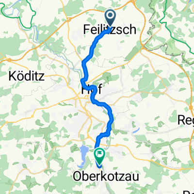
Zum Hänselstein 20, Feilitzsch nach Bahnhofstraße 1, Münchberg
A cycling route starting in Feilitzsch, Bavaria, Germany.
Overview
About this route
- 1 h 52 min
- Duration
- 30.6 km
- Distance
- 516 m
- Ascent
- 520 m
- Descent
- 16.4 km/h
- Avg. speed
- ---
- Max. altitude
Route quality
Waytypes & surfaces along the route
Waytypes
Busy road
9.9 km
(32 %)
Quiet road
6.9 km
(23 %)
Surfaces
Paved
14.1 km
(46 %)
Unpaved
4.9 km
(16 %)
Asphalt
12.8 km
(42 %)
Gravel
4.7 km
(15 %)
Continue with Bikemap
Use, edit, or download this cycling route
You would like to ride Zum Hänselstein 20, Feilitzsch nach Bahnhofstraße 1, Münchberg or customize it for your own trip? Here is what you can do with this Bikemap route:
Free features
- Save this route as favorite or in collections
- Copy & plan your own version of this route
- Sync your route with Garmin or Wahoo
Premium features
Free trial for 3 days, or one-time payment. More about Bikemap Premium.
- Navigate this route on iOS & Android
- Export a GPX / KML file of this route
- Create your custom printout (try it for free)
- Download this route for offline navigation
Discover more Premium features.
Get Bikemap PremiumFrom our community
Other popular routes starting in Feilitzsch
 Saaletour 2022
- Distance
- 170.3 km
- Ascent
- 3,021 m
- Descent
- 3,365 m
- Location
- Feilitzsch, Bavaria, Germany
 mödlar-unterha
- Distance
- 10.6 km
- Ascent
- 144 m
- Descent
- 151 m
- Location
- Feilitzsch, Bavaria, Germany
 Weidigstraße 9, Feilitzsch nach Steinweg 3, Feilitzsch
- Distance
- 10.1 km
- Ascent
- 220 m
- Descent
- 216 m
- Location
- Feilitzsch, Bavaria, Germany
 Sommertour 2016 "Grünesband"
- Distance
- 205 km
- Ascent
- 1,040 m
- Descent
- 1,192 m
- Location
- Feilitzsch, Bavaria, Germany
 rund um zedtwitz
- Distance
- 26.5 km
- Ascent
- 320 m
- Descent
- 321 m
- Location
- Feilitzsch, Bavaria, Germany
 Schnelle Tour in Oberkotzau
- Distance
- 14.6 km
- Ascent
- 251 m
- Descent
- 214 m
- Location
- Feilitzsch, Bavaria, Germany
 IronCurtainTrail 2014 (Zedtwitz)
- Distance
- 54.4 km
- Ascent
- 586 m
- Descent
- 586 m
- Location
- Feilitzsch, Bavaria, Germany
 A72, Feilitzsch nach Grobauer Weg 12, Feilitzsch
- Distance
- 6.1 km
- Ascent
- 67 m
- Descent
- 52 m
- Location
- Feilitzsch, Bavaria, Germany
Open it in the app