

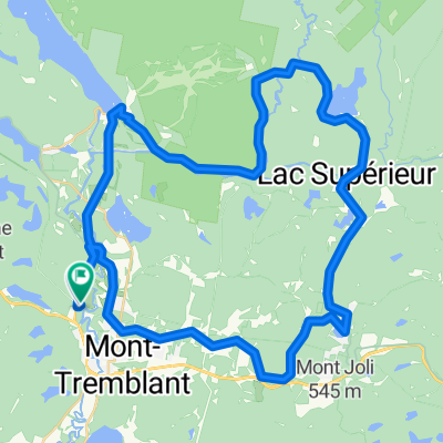
Défi VQ 2011-2 Mont-Tremblant
A cycling route starting in Mont-Tremblant, Quebec, Canada.
Overview
About this route
Route of the Défi du Mont-Tremblant 2011
Note: some sections of the road are unpaved (about 7 km in total)
- -:--
- Duration
- 153.2 km
- Distance
- 402 m
- Ascent
- 402 m
- Descent
- ---
- Avg. speed
- ---
- Max. altitude

Route quality
Waytypes & surfaces along the route
Waytypes
Road
70.5 km
(46 %)
Quiet road
7.7 km
(5 %)
Surfaces
Paved
133.3 km
(87 %)
Unpaved
7.7 km
(5 %)
Asphalt
128.7 km
(84 %)
Unpaved (undefined)
7.7 km
(5 %)
Route highlights
Points of interest along the route
Point of interest after 80.6 km
Pause Diner. Emplacement exact à confirmer
Continue with Bikemap
Use, edit, or download this cycling route
You would like to ride Défi VQ 2011-2 Mont-Tremblant or customize it for your own trip? Here is what you can do with this Bikemap route:
Free features
- Save this route as favorite or in collections
- Copy & plan your own version of this route
- Split it into stages to create a multi-day tour
- Sync your route with Garmin or Wahoo
Premium features
Free trial for 3 days, or one-time payment. More about Bikemap Premium.
- Navigate this route on iOS & Android
- Export a GPX / KML file of this route
- Create your custom printout (try it for free)
- Download this route for offline navigation
Discover more Premium features.
Get Bikemap PremiumFrom our community
Other popular routes starting in Mont-Tremblant
 250908 Saint Jovite to Saint Adèle
- Distance
- 52.4 km
- Ascent
- 332 m
- Descent
- 253 m
- Location
- Mont-Tremblant, Quebec, Canada
 boucle lac supérieur - St-Donat - Lac Montagne Noire - lac supérieur
- Distance
- 81.8 km
- Ascent
- 725 m
- Descent
- 725 m
- Location
- Mont-Tremblant, Quebec, Canada
 Défi VQ 2011-2 Mont-Tremblant
- Distance
- 153.2 km
- Ascent
- 402 m
- Descent
- 402 m
- Location
- Mont-Tremblant, Quebec, Canada
 51 km
51 km- Distance
- 51.5 km
- Ascent
- 276 m
- Descent
- 267 m
- Location
- Mont-Tremblant, Quebec, Canada
 Mont-Tremblant Loop
- Distance
- 50.8 km
- Ascent
- 302 m
- Descent
- 305 m
- Location
- Mont-Tremblant, Quebec, Canada
 defi de l ete vélo québec Tremblant
- Distance
- 88.7 km
- Ascent
- 344 m
- Descent
- 342 m
- Location
- Mont-Tremblant, Quebec, Canada
 Lac Superieur-Tremblant-Lac Quenouille
- Distance
- 66.2 km
- Ascent
- 451 m
- Descent
- 452 m
- Location
- Mont-Tremblant, Quebec, Canada
 1750 Rue Marie-Louise-Vallée, Mont-Tremblant to 1742 Rue Marie-Louise-Vallée, Mont-Tremblant
- Distance
- 56.9 km
- Ascent
- 953 m
- Descent
- 944 m
- Location
- Mont-Tremblant, Quebec, Canada
Open it in the app