Trainingsrunde 22,5 km zur Äpplerhöhe
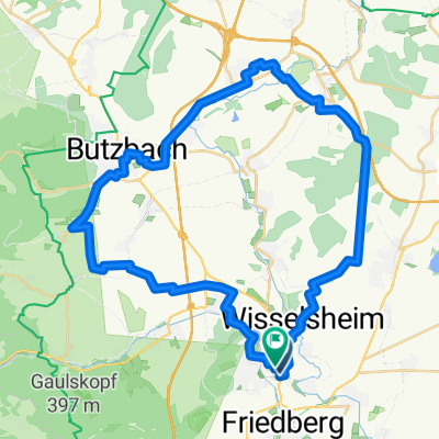
A cycling route starting in Bad Nauheim, Hesse, Germany.
Overview
About this route
Start-und Zielpunkt ist der Parkplatz am Steinfurther Sportplatz.
Die Strecke ist erst flach und geht dann leicht bergauf.
Ein Stück von ca. 400m auf der Römerstraße ab der Waldeinfahrt ist etwas anstrengend,
danach geht es aber wieder bergab über Münzenberg , Rockenberg und Oppershofen zum Zielpunkt.
- -:--
- Duration
- 22.4 km
- Distance
- 161 m
- Ascent
- 160 m
- Descent
- ---
- Avg. speed
- ---
- Avg. speed
Route quality
Waytypes & surfaces along the route
Waytypes
Track
15 km
(67 %)
Quiet road
3.1 km
(14 %)
Surfaces
Paved
18.3 km
(82 %)
Unpaved
3.5 km
(16 %)
Asphalt
15.5 km
(69 %)
Paved (undefined)
2.7 km
(12 %)
Route highlights
Points of interest along the route
Point of interest after 10.3 km
400m Anstieg
Point of interest after 13.2 km
Rastplatz Äpplerhöhe
Continue with Bikemap
Use, edit, or download this cycling route
You would like to ride Trainingsrunde 22,5 km zur Äpplerhöhe or customize it for your own trip? Here is what you can do with this Bikemap route:
Free features
- Save this route as favorite or in collections
- Copy & plan your own version of this route
- Sync your route with Garmin or Wahoo
Premium features
Free trial for 3 days, or one-time payment. More about Bikemap Premium.
- Navigate this route on iOS & Android
- Export a GPX / KML file of this route
- Create your custom printout (try it for free)
- Download this route for offline navigation
Discover more Premium features.
Get Bikemap PremiumFrom our community
Other popular routes starting in Bad Nauheim
- Zufahrt zur Trainingsrunde (Panzerstraße)
- Distance
- 2.6 km
- Ascent
- 61 m
- Descent
- 8 m
- Location
- Bad Nauheim, Hesse, Germany
- Friedberg - Münzenberg - Friedberg
- Distance
- 41.9 km
- Ascent
- 182 m
- Descent
- 197 m
- Location
- Bad Nauheim, Hesse, Germany
- Trainingsrunde 22,5 km zur Äpplerhöhe
- Distance
- 22.4 km
- Ascent
- 161 m
- Descent
- 160 m
- Location
- Bad Nauheim, Hesse, Germany
- Goethestraße 4, Bad Nauheim nach Schillerstraße 2, Bad Nauheim
- Distance
- 22.5 km
- Ascent
- 379 m
- Descent
- 427 m
- Location
- Bad Nauheim, Hesse, Germany
- Nach Inheiden auf ein Bier.
- Distance
- 55.5 km
- Ascent
- 284 m
- Descent
- 285 m
- Location
- Bad Nauheim, Hesse, Germany
- Biketour zur Münzenburg
- Distance
- 30.4 km
- Ascent
- 262 m
- Descent
- 262 m
- Location
- Bad Nauheim, Hesse, Germany
- TheBiker_lockereAusfahrt
- Distance
- 28.2 km
- Ascent
- 559 m
- Descent
- 536 m
- Location
- Bad Nauheim, Hesse, Germany
- Route zu Median Klinik Am Südpark Bad Nauheim
- Distance
- 33.6 km
- Ascent
- 384 m
- Descent
- 257 m
- Location
- Bad Nauheim, Hesse, Germany
Open it in the app