Grenzerfahrungen Teil 08 #BETA#
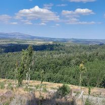
A cycling route starting in Benneckenstein, Saxony-Anhalt, Germany.
Overview
About this route
der Brocken! kurze Etappe mit Sightseeing.
- -:--
- Duration
- 55.9 km
- Distance
- 756 m
- Ascent
- 1,249 m
- Descent
- ---
- Avg. speed
- ---
- Avg. speed
Route quality
Waytypes & surfaces along the route
Waytypes
Track
27.4 km
(49 %)
Quiet road
15.2 km
(27 %)
Surfaces
Paved
29.2 km
(52 %)
Unpaved
25.9 km
(46 %)
Asphalt
25.8 km
(46 %)
Gravel
15.2 km
(27 %)
Route highlights
Points of interest along the route
Point of interest after 15.8 km
Point of interest after 18.2 km
Schnappes!
Point of interest after 29.4 km
dat isn Brocken!
Point of interest after 36.6 km
hier die Lu ihren Pokal gewonnen
Point of interest after 45.2 km
mgl. Übernachtung: Jugendherberge http://www.djh-niedersachsen.de/jh/schoeningen/
Point of interest after 49.4 km
mgl Übernachtung: http://www.gastgeber.net/84104.htm
Continue with Bikemap
Use, edit, or download this cycling route
You would like to ride Grenzerfahrungen Teil 08 #BETA# or customize it for your own trip? Here is what you can do with this Bikemap route:
Free features
- Save this route as favorite or in collections
- Copy & plan your own version of this route
- Sync your route with Garmin or Wahoo
Premium features
Free trial for 3 days, or one-time payment. More about Bikemap Premium.
- Navigate this route on iOS & Android
- Export a GPX / KML file of this route
- Create your custom printout (try it for free)
- Download this route for offline navigation
Discover more Premium features.
Get Bikemap PremiumFrom our community
Other popular routes starting in Benneckenstein
- 2025_Harz_Tanne_Wurmberg_58_1100
- Distance
- 58.2 km
- Ascent
- 989 m
- Descent
- 1,019 m
- Location
- Benneckenstein, Saxony-Anhalt, Germany
- Harz Tour 1. Tag - Freitag
- Distance
- 88.7 km
- Ascent
- 1,143 m
- Descent
- 1,207 m
- Location
- Benneckenstein, Saxony-Anhalt, Germany
- Hohegeiß - Bag Lauterberg - Braunlage - Hohegeiß 68 km 840HM
- Distance
- 68.1 km
- Ascent
- 682 m
- Descent
- 676 m
- Location
- Benneckenstein, Saxony-Anhalt, Germany
- Gipfelrunde Harz
- Distance
- 94.4 km
- Ascent
- 1,784 m
- Descent
- 1,813 m
- Location
- Benneckenstein, Saxony-Anhalt, Germany
- 2025_Harz_Tanne-Wurmberg_36-800
- Distance
- 35.8 km
- Ascent
- 790 m
- Descent
- 788 m
- Location
- Benneckenstein, Saxony-Anhalt, Germany
- Grenzerfahrungen Teil 08 #BETA#
- Distance
- 55.9 km
- Ascent
- 756 m
- Descent
- 1,249 m
- Location
- Benneckenstein, Saxony-Anhalt, Germany
- 2025_Harz_Tanne-Wurmberg_57-1200
- Distance
- 56.5 km
- Ascent
- 1,163 m
- Descent
- 1,164 m
- Location
- Benneckenstein, Saxony-Anhalt, Germany
- Harz eher flache Strecke
- Distance
- 90.4 km
- Ascent
- 943 m
- Descent
- 943 m
- Location
- Benneckenstein, Saxony-Anhalt, Germany
Open it in the app