

Mosel Saarbrücken-Koblenz
MoselSaar E2 Mettlach-Trier
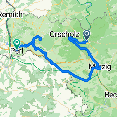
A cycling route starting in Mettlach, Saarland, Germany.
Overview
About this route
Mettlach Saarbrücke - Trier Kaiser-Wilhelm-Brücke
- -:--
- Duration
- 45.5 km
- Distance
- 158 m
- Ascent
- 188 m
- Descent
- ---
- Avg. speed
- ---
- Max. altitude
Part of
Mosel Saarbrücken-Koblenz
6 stages
Route quality
Waytypes & surfaces along the route
Waytypes
Path
30.5 km
(67 %)
Track
8.2 km
(18 %)
Surfaces
Paved
32.3 km
(71 %)
Unpaved
7.7 km
(17 %)
Asphalt
29.6 km
(65 %)
Gravel
6.8 km
(15 %)
Continue with Bikemap
Use, edit, or download this cycling route
You would like to ride MoselSaar E2 Mettlach-Trier or customize it for your own trip? Here is what you can do with this Bikemap route:
Free features
- Save this route as favorite or in collections
- Copy & plan your own version of this route
- Sync your route with Garmin or Wahoo
Premium features
Free trial for 3 days, or one-time payment. More about Bikemap Premium.
- Navigate this route on iOS & Android
- Export a GPX / KML file of this route
- Create your custom printout (try it for free)
- Download this route for offline navigation
Discover more Premium features.
Get Bikemap PremiumFrom our community
Other popular routes starting in Mettlach
 test 100km tour
- Distance
- 98.1 km
- Ascent
- 404 m
- Descent
- 404 m
- Location
- Mettlach, Saarland, Germany
 Saarschleife
- Distance
- 37.8 km
- Ascent
- 386 m
- Descent
- 385 m
- Location
- Mettlach, Saarland, Germany
 Saarschleifen-Runde
- Distance
- 20.2 km
- Ascent
- 411 m
- Descent
- 410 m
- Location
- Mettlach, Saarland, Germany
 Dreiländereck light
- Distance
- 68.1 km
- Ascent
- 644 m
- Descent
- 644 m
- Location
- Mettlach, Saarland, Germany
 Saar- , Mosel- & Rheinradweg von Mettlach bis Düsseldorf
- Distance
- 394.8 km
- Ascent
- 114 m
- Descent
- 251 m
- Location
- Mettlach, Saarland, Germany
 Mettlach, Saarburg, Konz
- Distance
- 70.4 km
- Ascent
- 354 m
- Descent
- 352 m
- Location
- Mettlach, Saarland, Germany
 3. Etappe - Heinertstraße, Mettlach nach Trierer Straße, Perl
- Distance
- 51.6 km
- Ascent
- 768 m
- Descent
- 711 m
- Location
- Mettlach, Saarland, Germany
 Zum Saarradweg über Aussicht
- Distance
- 13.3 km
- Ascent
- 323 m
- Descent
- 333 m
- Location
- Mettlach, Saarland, Germany
Open it in the app