


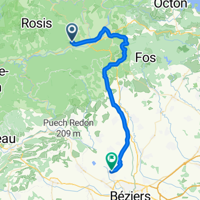
Lamalou les Bains -Agde
A cycling route starting in Lamalou-les-Bains, Occitanie, France.
Overview
About this route
0
- -:--
- Duration
- 80.8 km
- Distance
- 584 m
- Ascent
- 751 m
- Descent
- ---
- Avg. speed
- ---
- Max. altitude
Route quality
Waytypes & surfaces along the route
Waytypes
Road
23.4 km
29 %
Cycleway
12.1 km
15 %
Surfaces
Paved
46.1 km
(57 %)
Unpaved
4 km
(5 %)
Asphalt
45.3 km
56 %
Gravel
2.4 km
3 %
Continue with Bikemap
Use, edit, or download this cycling route
You would like to ride Lamalou les Bains -Agde or customize it for your own trip? Here is what you can do with this Bikemap route:
Free features
- Save this route as favorite or in collections
- Copy & plan your own version of this route
- Split it into stages to create a multi-day tour
- Sync your route with Garmin or Wahoo
Premium features
Free trial for 3 days, or one-time payment. More about Bikemap Premium.
- Navigate this route on iOS & Android
- Export a GPX / KML file of this route
- Create your custom printout (try it for free)
- Download this route for offline navigation
Discover more Premium features.
Get Bikemap PremiumFrom our community
Other popular routes starting in Lamalou-les-Bains


 De Route du Panissel 708, Rosis à Boulevard de Verdun 12 bis, Béziers0
- 47.1 km
- 656 m
- 1,036 m
- Lamalou-les-Bains, Occitanie, France


 Avenue Charcot, Lamalou-les-Bains à Rue Raymond Cau, Lignan-sur-Orb0
- 44.8 km
- 613 m
- 779 m
- Lamalou-les-Bains, Occitanie, France


Open it in the app