

Lac Viceroy & Barrierre
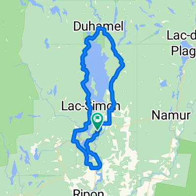
A cycling route starting in Saint-André-Avellin, Quebec, Canada.
Overview
About this route
- -:--
- Duration
- 28.9 km
- Distance
- 179 m
- Ascent
- 172 m
- Descent
- ---
- Avg. speed
- ---
- Max. altitude
Route quality
Waytypes & surfaces along the route
Waytypes
Road
11.5 km
(40 %)
Quiet road
11.5 km
(40 %)
Surfaces
Paved
15.6 km
(54 %)
Unpaved
12.4 km
(43 %)
Asphalt
15.6 km
(54 %)
Unpaved (undefined)
12.4 km
(43 %)
Undefined
0.9 km
(3 %)
Continue with Bikemap
Use, edit, or download this cycling route
You would like to ride Lac Viceroy & Barrierre or customize it for your own trip? Here is what you can do with this Bikemap route:
Free features
- Save this route as favorite or in collections
- Copy & plan your own version of this route
- Sync your route with Garmin or Wahoo
Premium features
Free trial for 3 days, or one-time payment. More about Bikemap Premium.
- Navigate this route on iOS & Android
- Export a GPX / KML file of this route
- Create your custom printout (try it for free)
- Download this route for offline navigation
Discover more Premium features.
Get Bikemap PremiumFrom our community
Other popular routes starting in Saint-André-Avellin
 De 1221 Ch du Vieux-Pin, St-André-Avellin à 1219 Ch du Vieux-Pin, St-André-Avellin
- Distance
- 41.6 km
- Ascent
- 727 m
- Descent
- 711 m
- Location
- Saint-André-Avellin, Quebec, Canada
 Lac Simon, 2021 Challenge
- Distance
- 47 km
- Ascent
- 366 m
- Descent
- 364 m
- Location
- Saint-André-Avellin, Quebec, Canada
 lac simon
- Distance
- 52.2 km
- Ascent
- 403 m
- Descent
- 425 m
- Location
- Saint-André-Avellin, Quebec, Canada
 Les Trois Lac
- Distance
- 61.7 km
- Ascent
- 427 m
- Descent
- 429 m
- Location
- Saint-André-Avellin, Quebec, Canada
 St-André / Thurso
- Distance
- 79.5 km
- Ascent
- 279 m
- Descent
- 276 m
- Location
- Saint-André-Avellin, Quebec, Canada
 St-André / Papineauville
- Distance
- 40 km
- Ascent
- 258 m
- Descent
- 258 m
- Location
- Saint-André-Avellin, Quebec, Canada
 Lac Viceroy & Barrierre
- Distance
- 28.9 km
- Ascent
- 179 m
- Descent
- 172 m
- Location
- Saint-André-Avellin, Quebec, Canada
 Tour du Lac Simon
- Distance
- 84.2 km
- Ascent
- 438 m
- Descent
- 441 m
- Location
- Saint-André-Avellin, Quebec, Canada
Open it in the app