

Beef Bend, April, Burgundy,150&Home
A cycling route starting in King City, Oregon, United States.
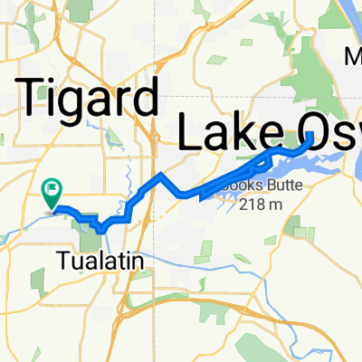
Overview
About this route
Beef Bend, April, Burgundy,150&Home
- -:--
- Duration
- 13.6 km
- Distance
- 164 m
- Ascent
- 162 m
- Descent
- ---
- Avg. speed
- ---
- Max. altitude

Route quality
Waytypes & surfaces along the route
Waytypes
Quiet road
5.6 km
(41 %)
Road
2 km
(15 %)
Undefined
6 km
(44 %)
Surfaces
Paved
6.8 km
(50 %)
Asphalt
6.8 km
(50 %)
Undefined
6.8 km
(50 %)
Continue with Bikemap
Use, edit, or download this cycling route
You would like to ride Beef Bend, April, Burgundy,150&Home or customize it for your own trip? Here is what you can do with this Bikemap route:
Free features
- Save this route as favorite or in collections
- Copy & plan your own version of this route
- Sync your route with Garmin or Wahoo
Premium features
Free trial for 3 days, or one-time payment. More about Bikemap Premium.
- Navigate this route on iOS & Android
- Export a GPX / KML file of this route
- Create your custom printout (try it for free)
- Download this route for offline navigation
Discover more Premium features.
Get Bikemap PremiumFrom our community
Other popular routes starting in King City
 53mi RTB Beginning
- Distance
- 82.4 km
- Ascent
- 625 m
- Descent
- 625 m
- Location
- King City, Oregon, United States
 Home to 99 Ranch- Fanno Creek
- Distance
- 10.6 km
- Ascent
- 102 m
- Descent
- 97 m
- Location
- King City, Oregon, United States
 Beef Bend, April, Burgundy,150&Home
- Distance
- 13.6 km
- Ascent
- 164 m
- Descent
- 162 m
- Location
- King City, Oregon, United States
 Safeway Royal Pkwy route Run
- Distance
- 6.2 km
- Ascent
- 102 m
- Descent
- 101 m
- Location
- King City, Oregon, United States
 Haag Lake
- Distance
- 38.4 km
- Ascent
- 89 m
- Descent
- 205 m
- Location
- King City, Oregon, United States
 11865 SW Tualatin Rd, Tualatin to 17005 SW 92nd Ave, Tigard
- Distance
- 8.2 km
- Ascent
- 30 m
- Descent
- 48 m
- Location
- King City, Oregon, United States
 bike-Lake O north shore Iron Mt. end & return
- Distance
- 33.2 km
- Ascent
- 437 m
- Descent
- 436 m
- Location
- King City, Oregon, United States
 South 124th loop past Murdock apts.
- Distance
- 27.8 km
- Ascent
- 194 m
- Descent
- 194 m
- Location
- King City, Oregon, United States
Open it in the app