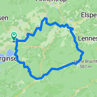
ATT, PanoPark, Heinsberg, Kruberg, Rhode
A cycling route starting in Attendorn, North Rhine-Westphalia, Germany.
Overview
About this route
schöne Rennstrecke: Silberg-Benolpe hinter Kruberg (Engelsberg) - Stachelau
- -:--
- Duration
- 98.3 km
- Distance
- 895 m
- Ascent
- 895 m
- Descent
- ---
- Avg. speed
- ---
- Avg. speed
Route quality
Waytypes & surfaces along the route
Waytypes
Quiet road
32.7 km
(33 %)
Path
24.7 km
(25 %)
Surfaces
Paved
85 km
(86 %)
Unpaved
1.5 km
(1 %)
Asphalt
82 km
(83 %)
Paved (undefined)
1.9 km
(2 %)
Continue with Bikemap
Use, edit, or download this cycling route
You would like to ride ATT, PanoPark, Heinsberg, Kruberg, Rhode or customize it for your own trip? Here is what you can do with this Bikemap route:
Free features
- Save this route as favorite or in collections
- Copy & plan your own version of this route
- Sync your route with Garmin or Wahoo
Premium features
Free trial for 3 days, or one-time payment. More about Bikemap Premium.
- Navigate this route on iOS & Android
- Export a GPX / KML file of this route
- Create your custom printout (try it for free)
- Download this route for offline navigation
Discover more Premium features.
Get Bikemap PremiumFrom our community
Other popular routes starting in Attendorn
- MTB Att,Heldener Höhe, Borghausen, Jäckelchen, Biggerandweg, Att.
- Distance
- 42.5 km
- Ascent
- 651 m
- Descent
- 653 m
- Location
- Attendorn, North Rhine-Westphalia, Germany
- Anspruchsvolle Rennradstrecke
- Distance
- 92.8 km
- Ascent
- 1,350 m
- Descent
- 1,296 m
- Location
- Attendorn, North Rhine-Westphalia, Germany
- Attendorn Hülschotte Frielentrop Attendorn
- Distance
- 32.2 km
- Ascent
- 728 m
- Descent
- 726 m
- Location
- Attendorn, North Rhine-Westphalia, Germany
- Rund um den Biggesee
- Distance
- 50.8 km
- Ascent
- 331 m
- Descent
- 331 m
- Location
- Attendorn, North Rhine-Westphalia, Germany
- Rund um Attendorn
- Distance
- 86.6 km
- Ascent
- 1,205 m
- Descent
- 1,205 m
- Location
- Attendorn, North Rhine-Westphalia, Germany
- Start - Ziel / Biken um Bigge und Lister
- Distance
- 42.4 km
- Ascent
- 594 m
- Descent
- 558 m
- Location
- Attendorn, North Rhine-Westphalia, Germany
- Rauterkusen, 4Kreuze, Höchsten, Illeschlade, Milstenau
- Distance
- 26.1 km
- Ascent
- 604 m
- Descent
- 606 m
- Location
- Attendorn, North Rhine-Westphalia, Germany
- 40er Nebenstrecken
- Distance
- 44.1 km
- Ascent
- 492 m
- Descent
- 492 m
- Location
- Attendorn, North Rhine-Westphalia, Germany
Open it in the app