

Fietsen langs 16 bossen
A cycling route starting in Oosterzele, Flemish Region, Belgium.
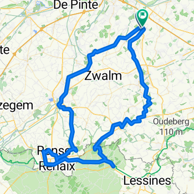
Overview
About this route
Cycling along 16 forests takes you via the node network past 16 beautiful forests and wooded areas in the region of Bottelare, Oosterzele, Munte, and Gavere. The route starts and ends near the café 't Ketske, where you can fully enjoy a drink in the beautiful courtyard at the end of your ride. This solid recreational cycling route is excellent for the more experienced cyclist or the cyclist with an e-bike. If you prefer a more relaxed pace, check out the shorter version of this route. You cycle past the following 16 forests: Sint-Annabos Gentbos Nat.res.Gondebeek Almoezenijbos Halve Maanbos Moortelbos Ettingebos Munkbos Harentbeekbos Makegembos Bruinbos Luisdonbos Nerenbos Bruinbos Heilig Geetsgoed Makenbos Practical Around the beautiful Sint-Anna church in Bottelare, there are many parking options. These are indicated on the map.
- 3 h 12 min
- Duration
- 50.3 km
- Distance
- 193 m
- Ascent
- 194 m
- Descent
- 15.7 km/h
- Avg. speed
- ---
- Max. altitude

Route quality
Waytypes & surfaces along the route
Waytypes
Quiet road
40.7 km
(81 %)
Road
3.5 km
(7 %)
Surfaces
Paved
14.1 km
(28 %)
Unpaved
0.5 km
(1 %)
Concrete
7.5 km
(15 %)
Asphalt
6.5 km
(13 %)
Continue with Bikemap
Use, edit, or download this cycling route
You would like to ride Fietsen langs 16 bossen or customize it for your own trip? Here is what you can do with this Bikemap route:
Free features
- Save this route as favorite or in collections
- Copy & plan your own version of this route
- Sync your route with Garmin or Wahoo
Premium features
Free trial for 3 days, or one-time payment. More about Bikemap Premium.
- Navigate this route on iOS & Android
- Export a GPX / KML file of this route
- Create your custom printout (try it for free)
- Download this route for offline navigation
Discover more Premium features.
Get Bikemap PremiumFrom our community
Other popular routes starting in Oosterzele
 Rekelberg-Leberg-Berendries
- Distance
- 70.4 km
- Ascent
- 301 m
- Descent
- 301 m
- Location
- Oosterzele, Flemish Region, Belgium
 Langs bossen en meersen fietsroute
- Distance
- 48.3 km
- Ascent
- 196 m
- Descent
- 194 m
- Location
- Oosterzele, Flemish Region, Belgium
 Vissershof
- Distance
- 54 km
- Ascent
- 222 m
- Descent
- 221 m
- Location
- Oosterzele, Flemish Region, Belgium
 mtb rond oosterzele
- Distance
- 38.1 km
- Ascent
- 190 m
- Descent
- 193 m
- Location
- Oosterzele, Flemish Region, Belgium
 Rodeland Route 2
- Distance
- 49.3 km
- Ascent
- 161 m
- Descent
- 162 m
- Location
- Oosterzele, Flemish Region, Belgium
 Oosterzele
- Distance
- 30.9 km
- Ascent
- 113 m
- Descent
- 113 m
- Location
- Oosterzele, Flemish Region, Belgium
 Route in Oosterzele
- Distance
- 102.7 km
- Ascent
- 888 m
- Descent
- 888 m
- Location
- Oosterzele, Flemish Region, Belgium
 Dender-Schelde
- Distance
- 57.2 km
- Ascent
- 215 m
- Descent
- 215 m
- Location
- Oosterzele, Flemish Region, Belgium
Open it in the app